Gogoşu night lights from space
Night Light of Gogoşu (Mehedinţi) from space (Romania) Src. Average luminocity for 10x10km area is 0.3667% and for 50x50km: 1.5804%.
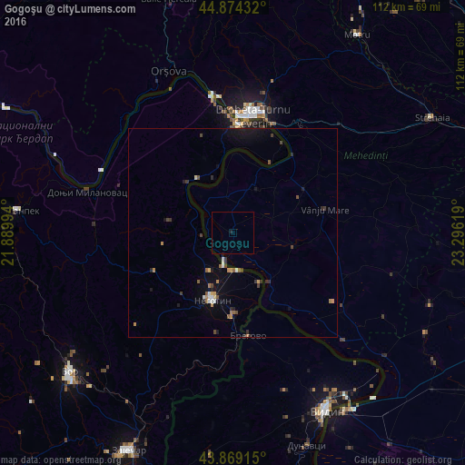
Analysis of Gogoşu night lights 2016
Square area 10x10 km:
 0%
0%90-99
0%80-89
0%70-79
0%60-69
0%50-59
0%40-49
0%30-39
0%20-29
0%10-19
0.63%0-9
99.37%Square area 50x50 km:
0.14%90-99
0.14%80-89
0.07%70-79
0.28%60-69
0.14%50-59
0.25%40-49
0.26%30-39
0.33%20-29
0.24%10-19
0.98%0-9
97.17%Clear (daylight) street map image can be seen on geolist.org.
Map coordinates:
44° 52' 27.6" North, 21° 53' 23.8" East
44° 22' 26" North, 22° 35' 35" East
43° 52' 8.9" North, 23° 17' 46.3" East
Some cities around Gogoşu sort by population:
• Drobeta-Turnu Severin
28.5 km =17.7 mi,  9°
9°
• Vidin, BG
48.4 km =30.1 mi,  151°
151°
• Negotin, RS
17.1 km =10.6 mi,  196°
196°
• Orşova
41.8 km =26 mi,  338°
338°
• Şimian
28.2 km =17.5 mi,  18°
18°
• Vânju-Mare
22.7 km =14.1 mi,  75°
75°
• Cetate
47.5 km =29.5 mi,  129°
129°
• Gârla-Mare
23.3 km =14.5 mi,  141°
141°
676976 (p: 5,309)
Sources (retrieved 2019-11-25):
» Earth at Night: Flat Maps 2012, 2016