Drăgăneşti night lights from space
Night Light of Drăgăneşti (Prahova) from space (Romania) Src. Average luminocity for 10x10km area is 1.1571% and for 50x50km: 6.4833%.
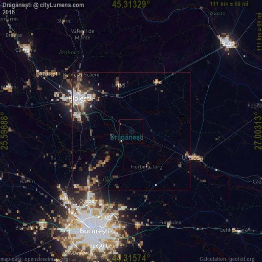
Analysis of Drăgăneşti night lights 2016
Square area 10x10 km:
 0%
0%90-99
0.63%80-89
0%70-79
0%60-69
0%50-59
0.63%40-49
0%30-39
0.63%20-29
0%10-19
0%0-9
98.1%Square area 50x50 km:
0.88%90-99
1.03%80-89
0.29%70-79
0.38%60-69
1.17%50-59
1.06%40-49
1.41%30-39
1.57%20-29
2.02%10-19
3.65%0-9
86.55%Clear (daylight) street map image can be seen on geolist.org.
Map coordinates:
45° 18' 47.8" North, 25° 35' 48.8" East
44° 49' 0" North, 26° 18' 0" East
44° 18' 56.7" North, 27° 0' 11.3" East
Some cities around Drăgăneşti sort by population:
• Puchenii Mari
17.1 km =10.6 mi,  270°
270°
• Gruiu
10.7 km =6.6 mi,  209°
209°
• Cioranii de Jos
9.2 km =5.7 mi,  90°
90°
• Snagov
15.9 km =9.9 mi,  215°
215°
• Albeşti-Paleologu
16.2 km =10.1 mi,  336°
336°
• Colceag
15.3 km =9.5 mi,  14°
14°
• Râfov
14.3 km =8.9 mi,  292°
292°
• Gorgota
17.5 km =10.9 mi,  257°
257°
679002 (p: 5,156)
Sources (retrieved 2019-11-25):
» Earth at Night: Flat Maps 2012, 2016