Botoroaga night lights from space
Night Light of Botoroaga (Teleorman) from space (Romania) Src. Average luminocity for 10x10km area is 0.2182% and for 50x50km: 1.3236%.
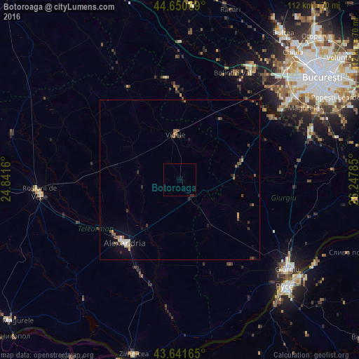
Analysis of Botoroaga night lights 2016
Square area 10x10 km:
 0%
0%90-99
0%80-89
0%70-79
0%60-69
0%50-59
0%40-49
0%30-39
0.3%20-29
0.3%10-19
0%0-9
99.39%Square area 50x50 km:
0.08%90-99
0.14%80-89
0.12%70-79
0.14%60-69
0.19%50-59
0.3%40-49
0.33%30-39
0.23%20-29
0.31%10-19
0.6%0-9
97.57%Clear (daylight) street map image can be seen on geolist.org.
Map coordinates:
44° 39' 2.5" North, 24° 50' 29.8" East
44° 8' 54" North, 25° 32' 41" East
43° 38' 29.9" North, 26° 14' 52.3" East
Some cities around Botoroaga sort by population:
• Alexandria
24.9 km =15.5 mi,  222°
222°
• Videle
14.5 km =9 mi,  353°
353°
• Roata de Jos
29.2 km =18.1 mi,  359°
359°
• Orbeasca de Sus
18.2 km =11.3 mi,  270°
270°
• Mihăileşti
35.1 km =21.8 mi,  55°
55°
• Băbăiţa
13 km =8.1 mi,  279°
279°
• Mavrodin
26.8 km =16.7 mi,  241°
241°
• Ţigăneşti
31.1 km =19.3 mi,  207°
207°
684045 (p: 6,488)
Sources (retrieved 2019-11-25):
» Earth at Night: Flat Maps 2012, 2016