Băneasa night lights from space
Night Light of Băneasa (Giurgiu) from space (Romania) Src. Average luminocity for 10x10km area is 0.7603% and for 50x50km: 4.3125%.
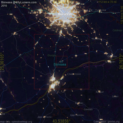
Analysis of Băneasa night lights 2016
Square area 10x10 km:
 0%
0%90-99
0%80-89
0%70-79
0%60-69
0%50-59
0%40-49
0%30-39
1.27%20-29
0.63%10-19
0.63%0-9
97.46%Square area 50x50 km:
0.48%90-99
0.64%80-89
0.49%70-79
0.53%60-69
0.46%50-59
0.55%40-49
0.9%30-39
0.86%20-29
1.19%10-19
2.78%0-9
91.12%Clear (daylight) street map image can be seen on geolist.org.
Map coordinates:
44° 32' 57.7" North, 25° 21' 39.8" East
44° 2' 46" North, 26° 3' 51" East
43° 32' 18.8" North, 26° 46' 2.3" East
Some cities around Băneasa sort by population:
• Ruse, BG
23.7 km =14.7 mi,  202°
202°
• Giurgiu
19.5 km =12.1 mi, 204°
• Vidra
25.3 km =15.7 mi,  19°
19°
• 1 Decembrie
27.2 km =16.9 mi,  358°
358°
• Comana
15.3 km =9.5 mi,  25°
25°
• Călugăreni
15 km =9.3 mi,  338°
338°
• Vărăşti
25.9 km =16.1 mi, 34°
• Frăteşti
11.8 km =7.3 mi,  221°
221°
685477 (p: 5,582)
Sources (retrieved 2019-11-25):
» Earth at Night: Flat Maps 2012, 2016