Albeştii Pământeni night lights from space
Night Light of Albeştii Pământeni (Arges) from space (Romania) Src. Average luminocity for 10x10km area is 2.4288% and for 50x50km: 1.5795%.
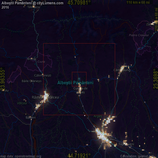
Analysis of Albeştii Pământeni night lights 2016
Square area 10x10 km:
 0%
0%90-99
0%80-89
0.61%70-79
0.61%60-69
0.61%50-59
0%40-49
0%30-39
0.61%20-29
0%10-19
0.91%0-9
96.67%Square area 50x50 km:
0.2%90-99
0.31%80-89
0.14%70-79
0.13%60-69
0.14%50-59
0.16%40-49
0.28%30-39
0.22%20-29
0.25%10-19
1.15%0-9
97.02%Clear (daylight) street map image can be seen on geolist.org.
Map coordinates:
45° 42' 35.3" North, 23° 57' 48.8" East
45° 13' 0" North, 24° 40' 0" East
44° 43' 9.2" North, 25° 22' 11.3" East
Some cities around Albeştii Pământeni sort by population:
• Râmnicu Vâlcea
26.9 km =16.7 mi,  241°
241°
• Curtea de Argeş
9.2 km =5.7 mi,  176°
176°
• Călimăneşti
26.2 km =16.3 mi,  274°
274°
• Băiculeşti
16.9 km =10.5 mi,  171°
171°
• Pietroşani
14.8 km =9.2 mi,  104°
104°
• Mihăeşti
28.4 km =17.6 mi,  113°
113°
• Corbeni
9.4 km =5.8 mi,  351°
351°
• Coşeşti
22.9 km =14.2 mi,  136°
136°
686544 (p: 5,815)
Sources (retrieved 2019-11-25):
» Earth at Night: Flat Maps 2012, 2016