Băiculeşti night lights from space
Night Light of Băiculeşti (Arges) from space (Romania) Src. Average luminocity for 10x10km area is 0.6985% and for 50x50km: 4.3899%.
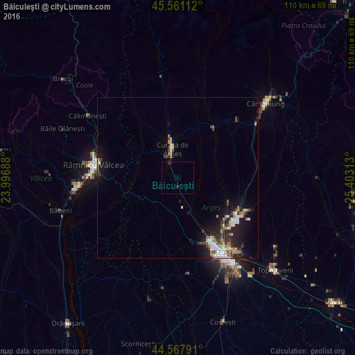
Analysis of Băiculeşti night lights 2016
Square area 10x10 km:
 0%
0%90-99
0%80-89
0%70-79
0%60-69
0%50-59
0%40-49
0%30-39
0.61%20-29
0.61%10-19
0.61%0-9
98.18%Square area 50x50 km:
0.7%90-99
0.77%80-89
0.29%70-79
0.46%60-69
0.49%50-59
0.44%40-49
0.72%30-39
0.66%20-29
1.51%10-19
3.45%0-9
90.52%Clear (daylight) street map image can be seen on geolist.org.
Map coordinates:
45° 33' 40" North, 23° 59' 48.8" East
45° 4' 0" North, 24° 42' 0" East
44° 34' 4.5" North, 25° 24' 11.3" East
Some cities around Băiculeşti sort by population:
• Curtea de Argeş
7.8 km =4.8 mi,  344°
344°
• Mioveni
22.5 km =14 mi,  122°
122°
• Başcov
20.7 km =12.9 mi,  153°
153°
• Pietroşani
17.5 km =10.9 mi,  42°
42°
• Mihăeşti
24.2 km =15 mi,  76°
76°
• Albeştii Pământeni
16.9 km =10.5 mi,  351°
351°
• Coşeşti
13.1 km =8.1 mi,  90°
90°
• Stâlpeni
21 km =13 mi,  95°
95°
685810 (p: 6,207)
Sources (retrieved 2019-11-25):
» Earth at Night: Flat Maps 2012, 2016