Santa Rita night lights from space
Night Light of Santa Rita (Alto Paraná) from space (Paraguay) Src. Average luminocity for 10x10km area is 22.375% and for 50x50km: 1.8025%.
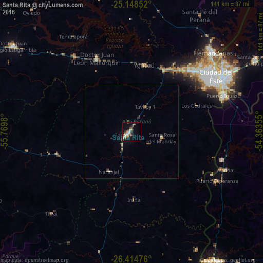
Analysis of Santa Rita night lights 2016
Square area 10x10 km:
 3.6%
3.6%90-99
3.98%80-89
3.03%70-79
0.95%60-69
3.6%50-59
2.08%40-49
2.84%30-39
4.55%20-29
1.89%10-19
18.18%0-9
55.3%Square area 50x50 km:
0.15%90-99
0.22%80-89
0.27%70-79
0.17%60-69
0.21%50-59
0.15%40-49
0.39%30-39
0.45%20-29
0.33%10-19
0.91%0-9
96.76%Clear (daylight) street map image can be seen on geolist.org.
Map coordinates:
25° 8' 54.7" South, 55° 46' 11.3" West
25° 46' 60" South, 55° 4' 0" West
26° 24' 53.1" South, 54° 21' 48.8" West
Some cities around Santa Rita sort by population:
• Ciudad del Este
54.9 km =34.1 mi,  56°
56°
• Foz do Iguaçu, BR
54.7 km =34 mi, 61°
• Presidente Franco
51.8 km =32.2 mi, 61°
• Puerto Iguazú, AR
53.5 km =33.2 mi,  67°
67°
• Puerto Esperanza, AR
52.6 km =32.7 mi,  120°
120°
• Wanda, AR
54.5 km =33.9 mi,  112°
112°
• Doctor Juan León Mallorquín
43.5 km =27 mi,  334°
334°
• Puerto Libertad, AR
50.8 km =31.6 mi, 107°
3436968 (p: 11,823)
Sources (retrieved 2019-11-25):
» Earth at Night: Flat Maps 2012, 2016