Vila Nova de Foz Côa night lights from space
Night Light of Vila Nova de Foz Côa (Guarda) from space (Portugal) Src. Average luminocity for 10x10km area is 6.7922% and for 50x50km: 3.3455%.
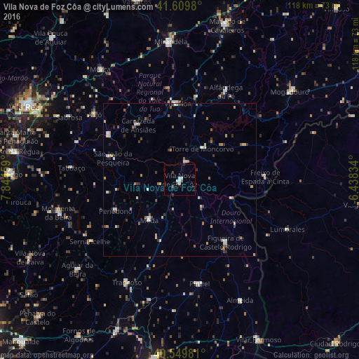
Analysis of Vila Nova de Foz Côa night lights 2016
Square area 10x10 km:
 1.3%
1.3%90-99
1.3%80-89
0.65%70-79
0%60-69
0%50-59
1.3%40-49
0.97%30-39
0.97%20-29
0.97%10-19
0.65%0-9
91.88%Square area 50x50 km:
0.21%90-99
0.63%80-89
0.45%70-79
0.39%60-69
0.38%50-59
0.53%40-49
0.44%30-39
0.66%20-29
0.66%10-19
0.25%0-9
95.4%Clear (daylight) street map image can be seen on geolist.org.
Map coordinates:
41° 36' 35.3" North, 7° 50' 40.5" West
41° 4' 55" North, 7° 8' 29.3" West
40° 32' 59.3" North, 6° 26' 18" West
Some cities around Vila Nova de Foz Côa sort by population:
• Custoias
15.3 km =9.5 mi,  279°
279°
• Alijó
35.3 km =21.9 mi,  307°
307°
• Moimenta da Beira
41.4 km =25.7 mi,  254°
254°
• Torre de Moncorvo
12.7 km =7.9 mi,  35°
35°
• São João da Pesqueira
23.3 km =14.5 mi,  288°
288°
• Carrazeda de Anciães
22.6 km =14 mi,  322°
322°
• Tabuaço
35.9 km =22.3 mi, 276°
• Sernancelhe
35.9 km =22.3 mi,  235°
235°
2732546 (p: 7,312)
Sources (retrieved 2019-11-25):
» Earth at Night: Flat Maps 2012, 2016