Carrazeda de Anciães night lights from space
Night Light of Carrazeda de Anciães (Bragança) from space (Portugal) Src. Average luminocity for 10x10km area is 5.6802% and for 50x50km: 4.4281%.
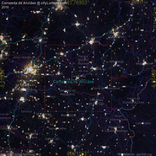
Analysis of Carrazeda de Anciães night lights 2016
Square area 10x10 km:
 0.16%
0.16%90-99
1.14%80-89
0%70-79
0.65%60-69
0%50-59
2.44%40-49
1.46%30-39
1.79%20-29
1.46%10-19
0%0-9
90.91%Square area 50x50 km:
0.26%90-99
0.71%80-89
0.57%70-79
0.3%60-69
0.56%50-59
0.67%40-49
0.77%30-39
0.89%20-29
0.99%10-19
0.39%0-9
93.9%Clear (daylight) street map image can be seen on geolist.org.
Map coordinates:
41° 46' 8.5" North, 8° 0' 37.2" West
41° 14' 32.9" North, 7° 18' 26" West
40° 42' 41.9" North, 6° 36' 14.7" West
Some cities around Carrazeda de Anciães sort by population:
• Custoias
15.3 km =9.5 mi,  184°
184°
• Alijó
14.5 km =9 mi,  285°
285°
• Torre de Moncorvo
22.5 km =14 mi,  109°
109°
• São João da Pesqueira
13.3 km =8.3 mi,  217°
217°
• Vila Nova de Foz Côa
22.6 km =14 mi,  142°
142°
• Sabrosa
22.6 km =14 mi,  276°
276°
• Tabuaço
25.9 km =16.1 mi,  237°
237°
• Vilela
24.8 km =15.4 mi,  265°
265°
2741431 (p: 6,373)
Sources (retrieved 2019-11-25):
» Earth at Night: Flat Maps 2012, 2016