São João das Lampas night lights from space
Night Light of São João das Lampas (Lisbon) from space (Portugal) Src. Average luminocity for 10x10km area is 54.6259% and for 50x50km: 37.8001%.
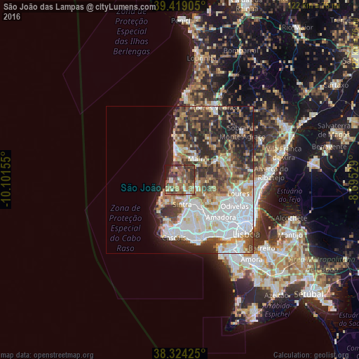
Analysis of São João das Lampas night lights 2016
Square area 10x10 km:
 2.89%
2.89%90-99
6.8%80-89
5.95%70-79
7.65%60-69
16.67%50-59
14.29%40-49
20.58%30-39
15.31%20-29
4.59%10-19
5.27%0-9
0%Square area 50x50 km:
10.88%90-99
7.77%80-89
3.46%70-79
3.54%60-69
5.15%50-59
5.1%40-49
5.19%30-39
6.28%20-29
8.28%10-19
7.27%0-9
37.08%Clear (daylight) street map image can be seen on geolist.org.
Map coordinates:
39° 25' 8.6" North, 10° 6' 5.6" West
38° 52' 25.5" North, 9° 23' 54.3" West
38° 19' 27.3" North, 8° 41' 43" West
Some cities around São João das Lampas sort by population:
• Algueirão
9.7 km =6 mi,  150°
150°
• Sintra
8.3 km =5.2 mi,  167°
167°
• Mafra
9.4 km =5.8 mi,  40°
40°
• Mem Martins
10 km =6.2 mi, 151°
• Almargem
11.3 km =7 mi,  106°
106°
• Colares
9.3 km =5.8 mi,  206°
206°
• Ericeira
10 km =6.2 mi,  351°
351°
• Fontanelas
4.6 km =2.9 mi,  231°
231°
2263327 (p: 10,484)
Sources (retrieved 2019-11-25):
» Earth at Night: Flat Maps 2012, 2016