Mafra night lights from space
Night Light of Mafra (Lisbon) from space (Portugal) Src. Average luminocity for 10x10km area is 50.1122% and for 50x50km: 40.7488%.
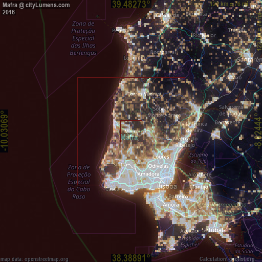
Analysis of Mafra night lights 2016
Square area 10x10 km:
 3.4%
3.4%90-99
7.14%80-89
8.67%70-79
4.08%60-69
8.33%50-59
9.01%40-49
12.59%30-39
21.77%20-29
25%10-19
0%0-9
0%Square area 50x50 km:
10.33%90-99
7.69%80-89
3.8%70-79
3.76%60-69
6.27%50-59
6.06%40-49
6.1%30-39
7.95%20-29
10.27%10-19
9.58%0-9
28.2%Clear (daylight) street map image can be seen on geolist.org.
Map coordinates:
39° 28' 57.8" North, 10° 1' 50.5" West
38° 56' 16.5" North, 9° 19' 39.2" West
38° 23' 20.1" North, 8° 37' 28" West
Some cities around Mafra sort by population:
• Algueirão
15.7 km =9.8 mi,  185°
185°
• Sintra
15.8 km =9.8 mi,  196°
196°
• São João das Lampas
9.4 km =5.8 mi,  220°
220°
• Mem Martins
16 km =9.9 mi,  184°
184°
• Almargem
11.4 km =7.1 mi,  155°
155°
• Ericeira
8.1 km =5 mi,  289°
289°
• Fontanelas
13.9 km =8.6 mi, 224°
• Milharado
11.2 km =7 mi,  84°
84°
2266865 (p: 12,259)
Sources (retrieved 2019-11-25):
» Earth at Night: Flat Maps 2012, 2016