São João night lights from space
Night Light of São João (Aveiro) from space (Portugal) Src. Average luminocity for 10x10km area is 58.6088% and for 50x50km: 31.1003%.
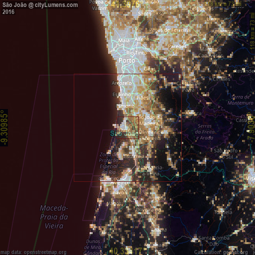
Analysis of São João night lights 2016
Square area 10x10 km:
100  5.1%
5.1%
90-99 8.84%
80-89 7.14%
70-79 7.31%
60-69 20.92%
50-59 18.37%
40-49 5.95%
30-39 12.07%
20-29 13.61%
10-19 0.68%
0-9 0%
5.1%90-99
8.84%80-89
7.14%70-79
7.31%60-69
20.92%50-59
18.37%40-49
5.95%30-39
12.07%20-29
13.61%10-19
0.68%0-9
0%Square area 50x50 km:
100 4.28%
90-99 6.1%
80-89 3.98%
70-79 4.87%
60-69 5.82%
50-59 4.48%
40-49 3.66%
30-39 4.9%
20-29 9.15%
10-19 11.2%
0-9 41.56%
4.28%90-99
6.1%80-89
3.98%70-79
4.87%60-69
5.82%50-59
4.48%40-49
3.66%30-39
4.9%20-29
9.15%10-19
11.2%0-9
41.56%Clear (daylight) street map image can be seen on geolist.org.
Map coordinates:
41° 23' 51.4" North, 9° 18' 35.5" West
40° 52' 4.9" North, 8° 36' 24.2" West
40° 20' 3" North, 7° 54' 13" West
Some cities around São João sort by population:
• Ovar
1.9 km =1.2 mi,  235°
235°
• Feira
8.3 km =5.2 mi,  40°
40°
• Esmoriz
10.1 km =6.3 mi,  350°
350°
• Cucujães
8.4 km =5.2 mi,  85°
85°
• Válega
4.2 km =2.6 mi,  148°
148°
• Arrifana
10.7 km =6.6 mi,  60°
60°
• Avanca
7.3 km =4.5 mi,  156°
156°
• São Roque
11.4 km =7.1 mi, 87°
2734493 (p: 6,762)
Sources (retrieved 2019-11-25):
» Earth at Night: Flat Maps 2012, 2016