Refojos de Basto night lights from space
Night Light of Refojos de Basto (Braga) from space (Portugal) Src. Average luminocity for 10x10km area is 22.2568% and for 50x50km: 16.4022%.
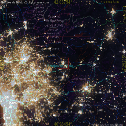
Analysis of Refojos de Basto night lights 2016
Square area 10x10 km:
 1.02%
1.02%90-99
3.74%80-89
1.36%70-79
3.91%60-69
3.06%50-59
4.42%40-49
1.87%30-39
4.93%20-29
4.59%10-19
24.49%0-9
46.6%Square area 50x50 km:
0.75%90-99
2.06%80-89
1.57%70-79
2.05%60-69
3.71%50-59
4.29%40-49
3.2%30-39
3.68%20-29
5.42%10-19
7.58%0-9
65.7%Clear (daylight) street map image can be seen on geolist.org.
Map coordinates:
42° 2' 15.1" North, 8° 41' 53.9" West
41° 30' 47.4" North, 7° 59' 42.6" West
40° 59' 4.3" North, 7° 17' 31.4" West
Some cities around Refojos de Basto sort by population:
• Felgueiras
23.1 km =14.4 mi,  225°
225°
• Guimarães
26.2 km =16.3 mi,  253°
253°
• Fafe
16.3 km =10.1 mi,  244°
244°
• Cabeceiras de Basto
0.5 km =0.3 mi,  75°
75°
• Margaride
23.7 km =14.7 mi, 225°
• Serzedo
22.9 km =14.2 mi, 238°
• Mondim de Basto
11.8 km =7.3 mi,  163°
163°
• Póvoa de Lanhoso
23.9 km =14.9 mi,  286°
286°
2735340 (p: 5,037)
Sources (retrieved 2019-11-25):
» Earth at Night: Flat Maps 2012, 2016