Khuzā‘ah night lights from space
Night Light of Khuzā‘ah (Gaza Strip) from space (Palestinian Territory) Src. Average luminocity for 10x10km area is 37.5472% and for 50x50km: 20.8078%.
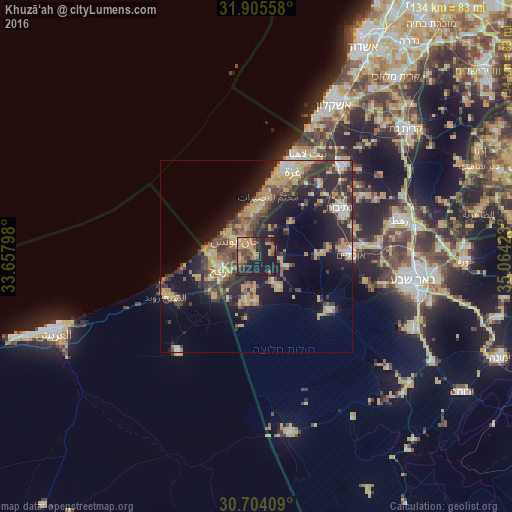
Analysis of Khuzā‘ah night lights 2016
Square area 10x10 km:
 0%
0%90-99
0.35%80-89
5.94%70-79
9.97%60-69
9.79%50-59
5.59%40-49
9.79%30-39
5.42%20-29
15.03%10-19
38.11%0-9
0%Square area 50x50 km:
1.42%90-99
1.66%80-89
3.36%70-79
4.69%60-69
2.53%50-59
2.42%40-49
4.63%30-39
4.38%20-29
7.92%10-19
13.87%0-9
53.12%Clear (daylight) street map image can be seen on geolist.org.
Map coordinates:
31° 54' 20.1" North, 33° 39' 28.7" East
31° 18' 24.3" North, 34° 21' 40" East
30° 42' 14.7" North, 35° 3' 51.2" East
Some cities around Khuzā‘ah sort by population:
• Khān Yūnis
6.4 km =4 mi,  305°
305°
• Banī Suhaylā
5.4 km =3.4 mi,  318°
318°
• Al Qarārah
7.7 km =4.8 mi,  345°
345°
• ‘Abasān al Kabīrah
2.4 km =1.5 mi,  304°
304°
• Shūkat aş Şūfī
9.1 km =5.7 mi,  235°
235°
• An Naşr
6.2 km =3.9 mi, 243°
• ‘Abasān al Jadīdah
4.1 km =2.5 mi,  339°
339°
• Al Fukhkhārī
3.3 km =2.1 mi, 241°
281119 (p: 9,023)
Sources (retrieved 2019-11-25):
» Earth at Night: Flat Maps 2012, 2016