Piotrków Kujawski night lights from space
Night Light of Piotrków Kujawski (Kujawsko-Pomorskie) from space (Poland) Src. Average luminocity for 10x10km area is 1.4735% and for 50x50km: 1.5862%.
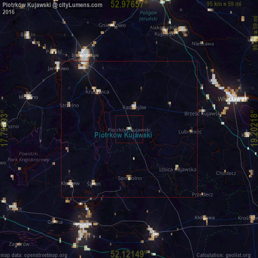
Analysis of Piotrków Kujawski night lights 2016
Square area 10x10 km:
 0%
0%90-99
0.53%80-89
0%70-79
0%60-69
0.26%50-59
0.79%40-49
0%30-39
0%20-29
0.53%10-19
0%0-9
97.88%Square area 50x50 km:
0.17%90-99
0.23%80-89
0.21%70-79
0.18%60-69
0.22%50-59
0.2%40-49
0.26%30-39
0.14%20-29
0.27%10-19
0.87%0-9
97.25%Clear (daylight) street map image can be seen on geolist.org.
Map coordinates:
52° 58' 35.7" North, 17° 47' 45.3" East
52° 33' 4" North, 18° 29' 56.6" East
52° 7' 17.4" North, 19° 12' 7.8" East
Some cities around Piotrków Kujawski sort by population:
• Inowrocław
31.8 km =19.8 mi,  330°
330°
• Mogilno
38.6 km =24 mi,  287°
287°
• Aleksandrów Kujawski
38.5 km =23.9 mi,  19°
19°
• Kruszwica
17.9 km =11.1 mi,  320°
320°
• Janikowo
34.4 km =21.4 mi,  310°
310°
• Gniewkowo
38.7 km =24 mi,  350°
350°
• Strzelno
23.7 km =14.7 mi, 291°
• Radziejów
8.4 km =5.2 mi,  13°
13°
3088977 (p: 5,030)
Sources (retrieved 2019-11-25):
» Earth at Night: Flat Maps 2012, 2016