Bolszewo night lights from space
Night Light of Bolszewo (Pomerania) from space (Poland) Src. Average luminocity for 10x10km area is 25.5639% and for 50x50km: 9.9526%.
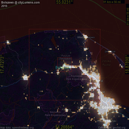
Analysis of Bolszewo night lights 2016
Square area 10x10 km:
 4.64%
4.64%90-99
4.51%80-89
2.26%70-79
2.38%60-69
3.13%50-59
3.26%40-49
3.26%30-39
2.13%20-29
1%10-19
35.46%0-9
37.97%Square area 50x50 km:
2.08%90-99
2.12%80-89
0.69%70-79
0.9%60-69
0.75%50-59
1.16%40-49
1.15%30-39
2.29%20-29
2.5%10-19
6%0-9
80.35%Clear (daylight) street map image can be seen on geolist.org.
Map coordinates:
55° 1' 23.2" North, 17° 28' 21.8" East
54° 37' 4.8" North, 18° 10' 33.1" East
54° 12' 31.8" North, 18° 52' 44.3" East
Some cities around Bolszewo sort by population:
• Gdynia
25.5 km =15.8 mi,  115°
115°
• Wejherowo
4.1 km =2.5 mi,  109°
109°
• Rumia
14.6 km =9.1 mi, 110°
• Reda
11.1 km =6.9 mi,  97°
97°
• Władysławowo
24.1 km =15 mi,  36°
36°
• Puck
18.6 km =11.6 mi,  53°
53°
• Luzino
7.2 km =4.5 mi,  216°
216°
• Gościcino
2 km =1.2 mi, 222°
3102961 (p: 7,064)
Sources (retrieved 2019-11-25):
» Earth at Night: Flat Maps 2012, 2016