Moog night lights from space
Night Light of Moog (Northern Mindanao) from space (Philippines) Src. Average luminocity for 10x10km area is 6.688% and for 50x50km: 4.2785%.
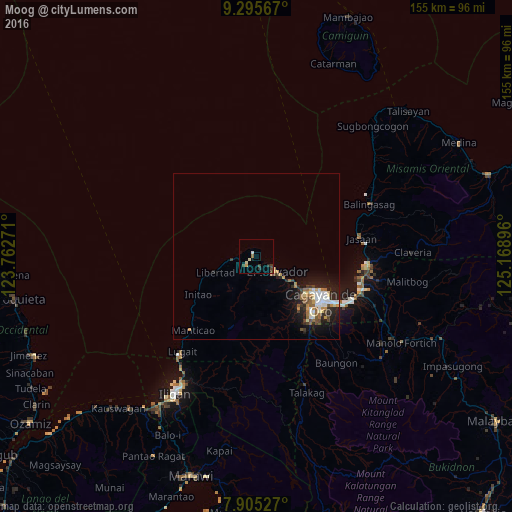
Analysis of Moog night lights 2016
Square area 10x10 km:
 0.41%
0.41%90-99
1.45%80-89
0.62%70-79
0.83%60-69
0.83%50-59
0%40-49
0.83%30-39
3.93%20-29
1.03%10-19
0%0-9
90.08%Square area 50x50 km:
0.63%90-99
0.67%80-89
0.41%70-79
0.56%60-69
0.5%50-59
0.57%40-49
0.59%30-39
0.62%20-29
1.41%10-19
2.98%0-9
91.04%Clear (daylight) street map image can be seen on geolist.org.
Map coordinates:
9° 17' 44.4" North, 123° 45' 45.8" East
8° 36' 4" North, 124° 27' 57" East
7° 54' 19" North, 125° 10' 8.3" East
Some cities around Moog sort by population:
• Cagayan de Oro
23.9 km =14.9 mi,  123°
123°
• Barra
18.3 km =11.4 mi, 123°
• Initao
21.1 km =13.1 mi,  237°
237°
• Molugan
12.7 km =7.9 mi, 123°
• Manticao
29.5 km =18.3 mi,  221°
221°
• Lumbia
26.8 km =16.7 mi,  148°
148°
• El Salvador
7.5 km =4.7 mi, 124°
• Igpit
16.7 km =10.4 mi,  127°
127°
1699246 (p: 5,197)
Sources (retrieved 2019-11-25):
» Earth at Night: Flat Maps 2012, 2016