Alcala night lights from space
Night Light of Alcala (Ilocos) from space (Philippines) Src. Average luminocity for 10x10km area is 0.4286% and for 50x50km: 5.2468%.
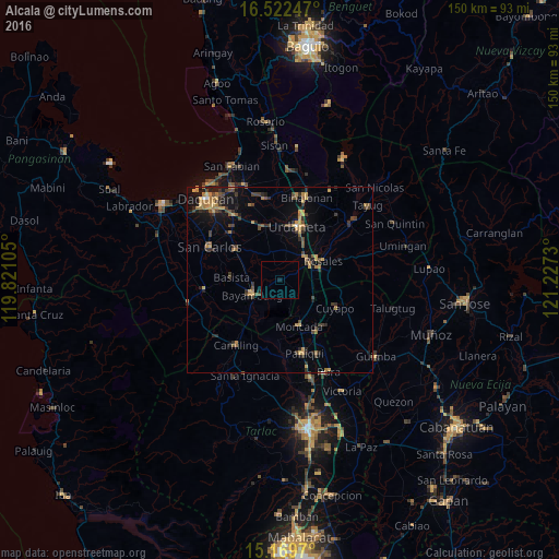
Analysis of Alcala night lights 2016
Square area 10x10 km:
100  0%
0%
90-99 0%
80-89 0%
70-79 0%
60-69 0%
50-59 0%
40-49 0%
30-39 0%
20-29 0%
10-19 0.87%
0-9 99.13%
0%90-99
0%80-89
0%70-79
0%60-69
0%50-59
0%40-49
0%30-39
0%20-29
0%10-19
0.87%0-9
99.13%Square area 50x50 km:
100 0.06%
90-99 0.06%
80-89 0.51%
70-79 1.2%
60-69 1.25%
50-59 0.49%
40-49 1.26%
30-39 1.56%
20-29 1.25%
10-19 3.08%
0-9 89.29%
0.06%90-99
0.06%80-89
0.51%70-79
1.2%60-69
1.25%50-59
0.49%40-49
1.26%30-39
1.56%20-29
1.25%10-19
3.08%0-9
89.29%Clear (daylight) street map image can be seen on geolist.org.
Map coordinates:
16° 31' 20.9" North, 119° 49' 15.8" East
15° 50' 50" North, 120° 31' 27" East
15° 10' 10.9" North, 121° 13' 38.3" East
Some cities around Alcala sort by population:
• Bayambang
8.3 km =5.2 mi,  242°
242°
• Villasis
9.2 km =5.7 mi,  48°
48°
• Rosales
12.7 km =7.9 mi,  65°
65°
• Carmen
9.2 km =5.7 mi,  61°
61°
• Lepa
8.9 km =5.5 mi,  297°
297°
• Puelay
6.9 km =4.3 mi, 50°
• Caramutan
12.3 km =7.6 mi, 48°
• Bacag
11.1 km =6.9 mi,  33°
33°
1731598 (p: 8,883)
Sources (retrieved 2019-11-25):
» Earth at Night: Flat Maps 2012, 2016