Puelay night lights from space
Night Light of Puelay (Ilocos) from space (Philippines) Src. Average luminocity for 10x10km area is 9.3442% and for 50x50km: 4.8695%.
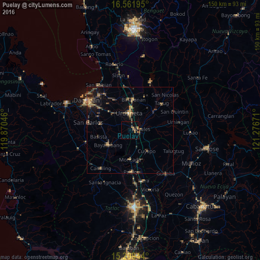
Analysis of Puelay night lights 2016
Square area 10x10 km:
100  0%
0%
90-99 0%
80-89 1.3%
70-79 1.73%
60-69 3.46%
50-59 1.08%
40-49 1.08%
30-39 2.38%
20-29 1.08%
10-19 2.81%
0-9 85.06%
0%90-99
0%80-89
1.3%70-79
1.73%60-69
3.46%50-59
1.08%40-49
1.08%30-39
2.38%20-29
1.08%10-19
2.81%0-9
85.06%Square area 50x50 km:
100 0.02%
90-99 0.02%
80-89 0.41%
70-79 1.08%
60-69 0.93%
50-59 0.58%
40-49 1.47%
30-39 1.63%
20-29 1.16%
10-19 2.74%
0-9 89.95%
0.02%90-99
0.02%80-89
0.41%70-79
1.08%60-69
0.93%50-59
0.58%40-49
1.47%30-39
1.63%20-29
1.16%10-19
2.74%0-9
89.95%Clear (daylight) street map image can be seen on geolist.org.
Map coordinates:
16° 33' 43" North, 119° 52' 13.7" East
15° 53' 12.6" North, 120° 34' 24.9" East
15° 12' 34" North, 121° 16' 36.2" East
Some cities around Puelay sort by population:
• Urdaneta
9.9 km =6.2 mi,  358°
358°
• Villasis
2.3 km =1.4 mi,  43°
43°
• Rosales
6.4 km =4 mi,  82°
82°
• Carmen
2.8 km =1.7 mi,  90°
90°
• Alcala
6.9 km =4.3 mi,  230°
230°
• Carusucan
11 km =6.8 mi, 37°
• Caramutan
5.4 km =3.4 mi,  46°
46°
• Bacag
4.9 km =3 mi,  10°
10°
1692699 (p: 6,854)
Sources (retrieved 2019-11-25):
» Earth at Night: Flat Maps 2012, 2016