La Mitra night lights from space
Night Light of La Mitra (Panamá Oeste) from space (Panama) Src. Average luminocity for 10x10km area is 44.9156% and for 50x50km: 12.4637%.
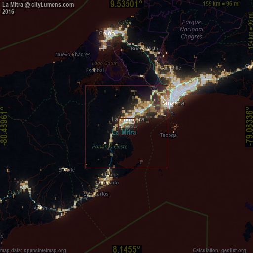
Analysis of La Mitra night lights 2016
Square area 10x10 km:
 8.01%
8.01%90-99
9.74%80-89
7.14%70-79
6.71%60-69
2.81%50-59
7.14%40-49
6.28%30-39
6.28%20-29
6.06%10-19
24.03%0-9
15.8%Square area 50x50 km:
1.1%90-99
1.61%80-89
1.89%70-79
1.75%60-69
1.95%50-59
2.47%40-49
2.04%30-39
2.59%20-29
4.26%10-19
6.33%0-9
74.02%Clear (daylight) street map image can be seen on geolist.org.
Map coordinates:
9° 32' 6" North, 80° 29' 22.6" West
8° 50' 27.3" North, 79° 47' 11.3" West
8° 8' 43.8" North, 79° 5' 0.1" West
Some cities around La Mitra sort by population:
• La Chorrera
4.4 km =2.7 mi,  4°
4°
• Nuevo Arraiján
11.8 km =7.3 mi,  38°
38°
• El Coco
3.8 km =2.4 mi,  329°
329°
• Vista Alegre
13.3 km =8.3 mi, 43°
• Altos de San Francisco
2.3 km =1.4 mi,  350°
350°
• La Pesa
4.2 km =2.6 mi,  284°
284°
• Guadalupe
3.4 km =2.1 mi,  296°
296°
• La Herradura
2.1 km =1.3 mi,  293°
293°
3707150 (p: 5,699)
Sources (retrieved 2019-11-25):
» Earth at Night: Flat Maps 2012, 2016