Almirante night lights from space
Night Light of Almirante (Bocas del Toro) from space (Panama) Src. Average luminocity for 10x10km area is 4.9697% and for 50x50km: 0.6036%.
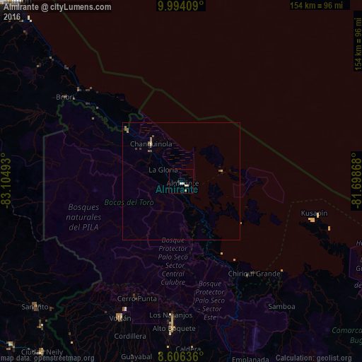
Analysis of Almirante night lights 2016
Square area 10x10 km:
 1.3%
1.3%90-99
2.16%80-89
0.87%70-79
0%60-69
0%50-59
0%40-49
0%30-39
0.87%20-29
0%10-19
0%0-9
94.81%Square area 50x50 km:
0.05%90-99
0.12%80-89
0.1%70-79
0.03%60-69
0.1%50-59
0.09%40-49
0.18%30-39
0.14%20-29
0%10-19
0.07%0-9
99.12%Clear (daylight) street map image can be seen on geolist.org.
Map coordinates:
9° 59' 38.7" North, 83° 6' 17.7" West
9° 18' 3.3" North, 82° 24' 6.5" West
8° 36' 22.9" North, 81° 41' 55.2" West
Some cities around Almirante sort by population:
• Changuinola
19.3 km =12 mi,  317°
317°
• La Concepción
90.9 km =56.5 mi,  195°
195°
• El Empalme
18 km =11.2 mi, 315°
• Volcán
64.2 km =39.9 mi, 203°
• Corredor, CR
94.7 km =58.8 mi,  219°
219°
• Boquete
58.1 km =36.1 mi,  184°
184°
• San Pablo Viejo Abajo
94.9 km =59 mi,  186°
186°
• Bocas del Toro
18.1 km =11.2 mi,  75°
75°
3714896 (p: 8,744)
Sources (retrieved 2019-11-25):
» Earth at Night: Flat Maps 2012, 2016