Vadsø night lights from space
Night Light of Vadsø (Finnmark) from space (Norway) Src. Average luminocity for 10x10km area is 8.8445% and for 50x50km: 0.5349%.
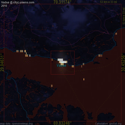
Analysis of Vadsø night lights 2016
Square area 10x10 km:
 1.79%
1.79%90-99
2.68%80-89
0.3%70-79
0.89%60-69
0.89%50-59
0%40-49
1.19%30-39
0%20-29
0%10-19
4.39%0-9
87.87%Square area 50x50 km:
0.08%90-99
0.11%80-89
0.01%70-79
0.05%60-69
0.07%50-59
0.02%40-49
0.17%30-39
0.11%20-29
0%10-19
0.17%0-9
99.2%Clear (daylight) street map image can be seen on geolist.org.
Map coordinates:
70° 18' 42.3" North, 29° 2' 46.7" East
70° 4' 24.5" North, 29° 44' 57.9" East
69° 49' 56.9" North, 30° 27' 9.2" East
Some cities around Vadsø sort by population:
• Zapolyarnyy, RU
83.9 km =52.1 mi,  150°
150°
• Polyarnyy, RU
173 km =107.5 mi,  124°
124°
• Nikel, RU
75.7 km =47 mi,  166°
166°
• Gadzhiyevo, RU
165.8 km =103 mi, 123°
• Zaozërsk, RU
128 km =79.5 mi,  125°
125°
• Snezhnogorsk, RU
167.2 km =103.9 mi, 125°
• Vidyayevo, RU
144.7 km =89.9 mi, 125°
• Inari, FI
167.6 km =104.1 mi,  219°
219°
777073 (p: 5,139)
Sources (retrieved 2019-11-25):
» Earth at Night: Flat Maps 2012, 2016