's-Gravenland night lights from space
Night Light of 's-Gravenland (South Holland) from space (Netherlands) Src. Average luminocity for 10x10km area is 93.803% and for 50x50km: 48.4643%.
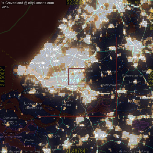
Analysis of 's-Gravenland night lights 2016
Square area 10x10 km:
 47.85%
90-99
30.93%80-89
9.72%70-79
5.81%60-69
2.53%50-59
1.01%40-49
2.02%30-39
0.13%20-29
0%10-19
0%0-9
0%Square area 50x50 km:
20.01%90-99
12.05%80-89
3.16%70-79
3.51%60-69
4.26%50-59
3.29%40-49
3.1%30-39
4.27%20-29
6.21%10-19
10.97%0-9
29.18%Clear (daylight) street map image can be seen on geolist.org.
Map coordinates:
52° 21' 17.6" North, 3° 51' 0.1" East
51° 55' 24.1" North, 4° 33' 11.3" East
51° 29' 15.5" North, 5° 15' 22.6" East
Some cities around 's-Gravenland sort by population:
• Capelle aan den IJssel
1.8 km =1.1 mi,  69°
69°
• Krimpen aan den IJssel
3.5 km =2.2 mi,  102°
102°
• Groot IJsselmonde
4.5 km =2.8 mi,  183°
183°
• Ommoord
4.1 km =2.5 mi,  352°
352°
• Vreewijk
4.9 km =3 mi,  207°
207°
• Bloemhof
4.7 km =2.9 mi,  231°
231°
• Bolnes
3.6 km =2.2 mi,  150°
150°
• Feijenoord
3.5 km =2.2 mi,  247°
247°
8379268 (p: 10,000)
Sources (retrieved 2019-11-25):
» Earth at Night: Flat Maps 2012, 2016