Pendrecht night lights from space
Night Light of Pendrecht (South Holland) from space (Netherlands) Src. Average luminocity for 10x10km area is 85.6528% and for 50x50km: 48.3107%.
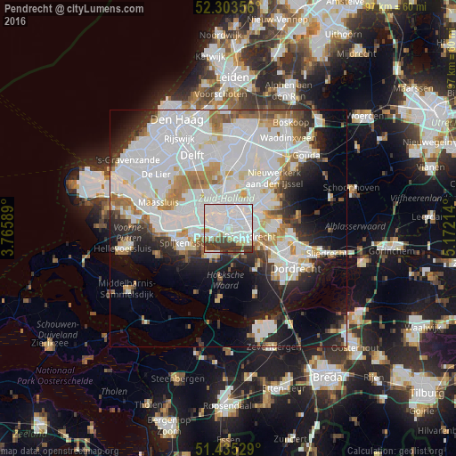
Analysis of Pendrecht night lights 2016
Square area 10x10 km:
 45.96%
90-99
26.64%80-89
3.03%70-79
2.4%60-69
2.4%50-59
1.64%40-49
6.82%30-39
10.98%20-29
0.13%10-19
0%0-9
0%Square area 50x50 km:
20.63%90-99
12.28%80-89
3.25%70-79
3.34%60-69
4.17%50-59
2.9%40-49
2.3%30-39
3.85%20-29
6.26%10-19
10.19%0-9
30.83%Clear (daylight) street map image can be seen on geolist.org.
Map coordinates:
52° 18' 12.8" North, 3° 45' 57.2" East
51° 52' 17.5" North, 4° 28' 8.4" East
51° 26' 7" North, 5° 10' 19.7" East
Some cities around Pendrecht sort by population:
• Barendrecht
4.8 km =3 mi,  110°
110°
• Rhoon
3.6 km =2.2 mi,  244°
244°
• Lombardijen
3.6 km =2.2 mi,  86°
86°
• Vreewijk
3.8 km =2.4 mi,  67°
67°
• Bloemhof
3.5 km =2.2 mi,  36°
36°
• Zuidwijk
1.2 km =0.7 mi, 69°
• Carnisse
2.1 km =1.3 mi,  16°
16°
• Delfshaven
3.9 km =2.4 mi,  343°
343°
2748657 (p: 11,885)
Sources (retrieved 2019-11-25):
» Earth at Night: Flat Maps 2012, 2016