Buitenpost night lights from space
Night Light of Buitenpost (Friesland) from space (Netherlands) Src. Average luminocity for 10x10km area is 0.6402% and for 50x50km: 2.9573%.
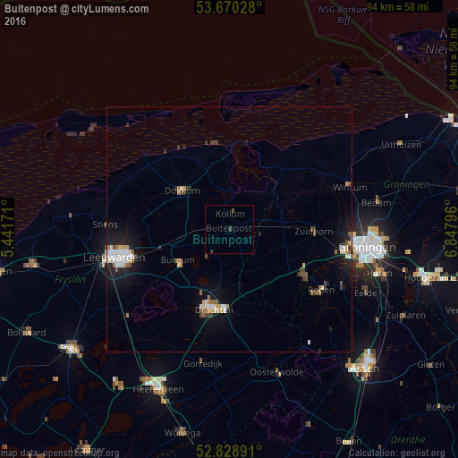
Analysis of Buitenpost night lights 2016
Square area 10x10 km:
 0%
0%90-99
0%80-89
0%70-79
0%60-69
0%50-59
0.51%40-49
0.51%30-39
0.51%20-29
0%10-19
0%0-9
98.48%Square area 50x50 km:
0.42%90-99
0.56%80-89
0.22%70-79
0.3%60-69
0.32%50-59
0.39%40-49
0.37%30-39
0.29%20-29
0.47%10-19
2.62%0-9
94.04%Clear (daylight) street map image can be seen on geolist.org.
Map coordinates:
53° 40' 13" North, 5° 26' 30.2" East
53° 15' 6" North, 6° 8' 41.4" East
52° 49' 44.1" North, 6° 50' 52.7" East
Some cities around Buitenpost sort by population:
• Drachten
15.8 km =9.8 mi,  191°
191°
• Dokkum
12.6 km =7.8 mi,  308°
308°
• Burgum
12.2 km =7.6 mi,  237°
237°
• Damwâld
10.7 km =6.6 mi,  293°
293°
• Surhuisterveen
7.6 km =4.7 mi,  167°
167°
• Kollum
2.9 km =1.8 mi,  10°
10°
• Marum
14.3 km =8.9 mi,  146°
146°
• De Westereen
7.2 km =4.5 mi,  274°
274°
2758131 (p: 5,120)
Sources (retrieved 2019-11-25):
» Earth at Night: Flat Maps 2012, 2016