Bodegraven night lights from space
Night Light of Bodegraven (South Holland) from space (Netherlands) Src. Average luminocity for 10x10km area is 29.8955% and for 50x50km: 46.5815%.
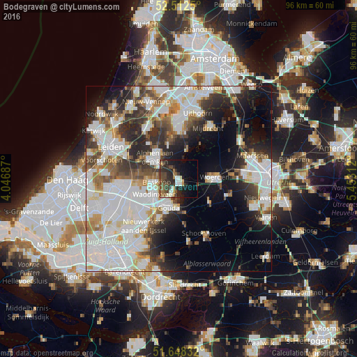
Analysis of Bodegraven night lights 2016
Square area 10x10 km:
 3.31%
3.31%90-99
4.5%80-89
1.59%70-79
2.38%60-69
4.63%50-59
5.03%40-49
8.47%30-39
6.35%20-29
15.61%10-19
16.4%0-9
31.75%Square area 50x50 km:
15.81%90-99
12.02%80-89
3.07%70-79
3.67%60-69
4.47%50-59
4.06%40-49
4.71%30-39
5.41%20-29
8.63%10-19
11.21%0-9
26.92%Clear (daylight) street map image can be seen on geolist.org.
Map coordinates:
52° 30' 45" North, 4° 2' 48.7" East
52° 4' 57" North, 4° 45' 0" East
51° 38' 54" North, 5° 27' 11.2" East
Some cities around Bodegraven sort by population:
• Gouda
7.9 km =4.9 mi,  201°
201°
• Alphen aan den Rijn
8.3 km =5.2 mi,  308°
308°
• Woerden
9.1 km =5.7 mi,  88°
88°
• Waddinxveen
7.9 km =4.9 mi,  238°
238°
• Boskoop
6.5 km =4 mi,  262°
262°
• Reeuwijk
4.3 km =2.7 mi, 203°
• Bloemendaal
7.1 km =4.4 mi,  212°
212°
• Groenswaard
7.9 km =4.9 mi, 244°
2758765 (p: 19,395)
Sources (retrieved 2019-11-25):
» Earth at Night: Flat Maps 2012, 2016