Bergschenhoek night lights from space
Night Light of Bergschenhoek (South Holland) from space (Netherlands) Src. Average luminocity for 10x10km area is 95.9962% and for 50x50km: 53.9412%.
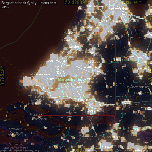
Analysis of Bergschenhoek night lights 2016
Square area 10x10 km:
 52.78%
90-99
33.08%80-89
6.82%70-79
5.3%60-69
1.26%50-59
0.76%40-49
0%30-39
0%20-29
0%10-19
0%0-9
0%Square area 50x50 km:
21.92%90-99
13.74%80-89
3.53%70-79
3.84%60-69
4.98%50-59
3.56%40-49
3.69%30-39
5.48%20-29
8.6%10-19
8.78%0-9
21.88%Clear (daylight) street map image can be seen on geolist.org.
Map coordinates:
52° 25' 15.2" North, 3° 47' 43.8" East
51° 59' 24" North, 4° 29' 55" East
51° 33' 17.7" North, 5° 12' 6.3" East
Some cities around Bergschenhoek sort by population:
• Ommoord
4.7 km =2.9 mi,  136°
136°
• Berkel en Rodenrijs
1.4 km =0.9 mi,  284°
284°
• Pijnacker
5.8 km =3.6 mi,  304°
304°
• Schiebroek
4 km =2.5 mi,  208°
208°
• Bleiswijk
3.3 km =2.1 mi,  44°
44°
• Overschie
7.5 km =4.7 mi,  220°
220°
• Driemanspolder
6.9 km =4.3 mi,  352°
352°
• Palenstein
7.3 km =4.5 mi,  5°
5°
2759113 (p: 16,579)
Sources (retrieved 2019-11-25):
» Earth at Night: Flat Maps 2012, 2016