Bleiswijk night lights from space
Night Light of Bleiswijk (South Holland) from space (Netherlands) Src. Average luminocity for 10x10km area is 98.3346% and for 50x50km: 54.2452%.
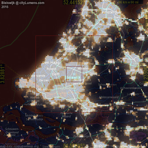
Analysis of Bleiswijk night lights 2016
Square area 10x10 km:
 63.64%
90-99
30.68%80-89
4.67%70-79
1.01%60-69
0%50-59
0%40-49
0%30-39
0%20-29
0%10-19
0%0-9
0%Square area 50x50 km:
21.71%90-99
13.75%80-89
3.54%70-79
4.09%60-69
5%50-59
3.92%40-49
4.11%30-39
5.57%20-29
8.31%10-19
8.79%0-9
21.22%Clear (daylight) street map image can be seen on geolist.org.
Map coordinates:
52° 26' 29.5" North, 3° 49' 43.7" East
52° 0' 39" North, 4° 31' 55" East
51° 34' 33.4" North, 5° 14' 6.2" East
Some cities around Bleiswijk sort by population:
• Zoetermeer
5.8 km =3.6 mi,  332°
332°
• Ommoord
5.8 km =3.6 mi,  170°
170°
• Berkel en Rodenrijs
4.1 km =2.5 mi,  241°
241°
• Pijnacker
7.1 km =4.4 mi,  277°
277°
• Bergschenhoek
3.3 km =2.1 mi,  224°
224°
• Schiebroek
7.2 km =4.5 mi, 215°
• Driemanspolder
5.6 km =3.5 mi,  324°
324°
• Palenstein
5.2 km =3.2 mi,  342°
342°
2758838 (p: 10,549)
Sources (retrieved 2019-11-25):
» Earth at Night: Flat Maps 2012, 2016