Benthuizen night lights from space
Night Light of Benthuizen (South Holland) from space (Netherlands) Src. Average luminocity for 10x10km area is 72.127% and for 50x50km: 53.7189%.
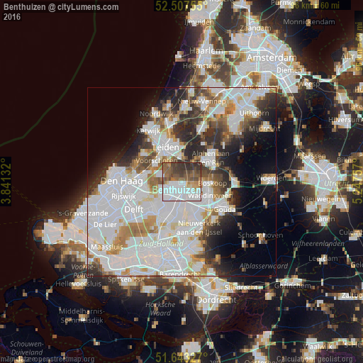
Analysis of Benthuizen night lights 2016
Square area 10x10 km:
 30.95%
90-99
12.43%80-89
2.25%70-79
4.5%60-69
9.39%50-59
13.1%40-49
11.77%30-39
13.1%20-29
2.51%10-19
0%0-9
0%Square area 50x50 km:
22.03%90-99
13.93%80-89
3.05%70-79
4.23%60-69
5.11%50-59
3.8%40-49
3.98%30-39
5.1%20-29
7.55%10-19
7.05%0-9
24.18%Clear (daylight) street map image can be seen on geolist.org.
Map coordinates:
52° 30' 27.2" North, 3° 50' 28.8" East
52° 4' 39" North, 4° 32' 40" East
51° 38' 35.8" North, 5° 14' 51.3" East
Some cities around Benthuizen sort by population:
• Zoetermeer
4.2 km =2.6 mi,  237°
237°
• Waddinxveen
8.2 km =5.1 mi,  116°
116°
• Voorschoten
8.6 km =5.3 mi,  310°
310°
• Boskoop
7.6 km =4.7 mi,  92°
92°
• Bleiswijk
7.5 km =4.7 mi,  186°
186°
• Driemanspolder
5 km =3.1 mi,  234°
234°
• Palenstein
3.4 km =2.1 mi, 225°
• Groenswaard
7.5 km =4.7 mi,  112°
112°
2759178 (p: 18,959)
Sources (retrieved 2019-11-25):
» Earth at Night: Flat Maps 2012, 2016