Tampin night lights from space
Night Light of Tampin (Negeri Sembilan) from space (Malaysia) Src. Average luminocity for 10x10km area is 50.684% and for 50x50km: 28.4058%.
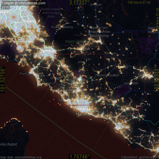

Analysis of Tampin night lights 2016
Square area 10x10 km:
 7.14%
7.14%90-99
6.28%80-89
4.76%70-79
6.71%60-69
6.71%50-59
13.85%40-49
14.07%30-39
13.2%20-29
16.23%10-19
11.04%0-9
0%Square area 50x50 km:
3.12%90-99
3.8%80-89
2.51%70-79
3.18%60-69
5.25%50-59
5.66%40-49
5.96%30-39
5.75%20-29
9.39%10-19
17.84%0-9
37.52%Clear (daylight) street map image can be seen on geolist.org.
Map coordinates:
3° 10' 20.5" North, 101° 31' 37.5" East
2° 28' 12.4" North, 102° 13' 48.7" East
1° 46' 2.9" North, 102° 55' 60" East
Some cities around Tampin sort by population:
• Kampung Ayer Keroh
23.4 km =14.5 mi,  166°
166°
• Kampong Masjid Tanah
18.4 km =11.4 mi,  223°
223°
• Sungai Udang
24.4 km =15.2 mi,  203°
203°
• Batu Berendam
24.7 km =15.3 mi,  175°
175°
• Alor Gajah
10.3 km =6.4 mi,  193°
193°
• Bukit Rambai
24 km =14.9 mi, 192°
• Kuala Sungai Baru
24.9 km =15.5 mi,  240°
240°
• Pulau Sebang
1.7 km =1.1 mi, 169°
1734738 (p: 28,238)
Sources (retrieved 2019-11-25):
» Earth at Night: Flat Maps 2012, 2016