Sungai Pelek New Village night lights from space
Night Light of Sungai Pelek New Village (Selangor) from space (Malaysia) Src. Average luminocity for 10x10km area is 32.6364% and for 50x50km: 30.576%.
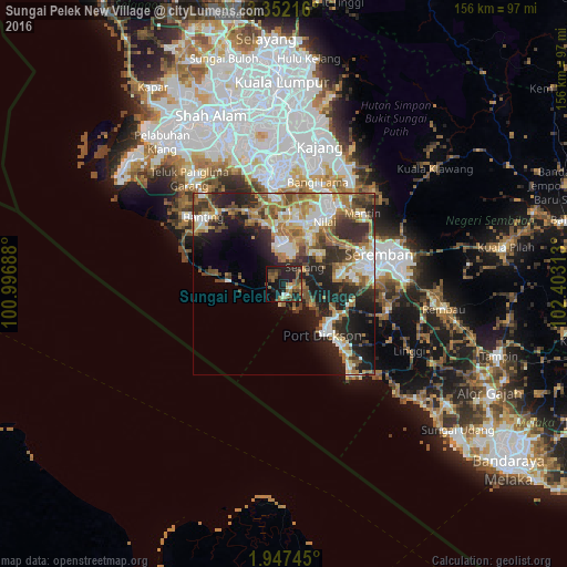
Analysis of Sungai Pelek New Village night lights 2016
Square area 10x10 km:
 1.08%
1.08%90-99
1.52%80-89
2.6%70-79
1.52%60-69
9.31%50-59
10.17%40-49
9.74%30-39
4.55%20-29
16.02%10-19
31.17%0-9
12.34%Square area 50x50 km:
4.23%90-99
5.7%80-89
3.21%70-79
3.97%60-69
6.19%50-59
4.7%40-49
5.07%30-39
4.39%20-29
9.64%10-19
13.18%0-9
39.72%Clear (daylight) street map image can be seen on geolist.org.
Map coordinates:
3° 21' 7.8" North, 100° 59' 48.8" East
2° 39' 0" North, 101° 42' 0" East
1° 56' 50.8" North, 102° 24' 11.3" East
Some cities around Sungai Pelek New Village sort by population:
• Seremban
27.9 km =17.3 mi,  71°
71°
• Sepang
7.3 km =4.5 mi,  49°
49°
• Port Dickson
17.2 km =10.7 mi,  136°
136°
• Putrajaya
31.7 km =19.7 mi,  358°
358°
• Banting
28.6 km =17.8 mi,  309°
309°
• Kampung Baharu Nilai
20.2 km =12.6 mi,  32°
32°
• Jenjarum
33.6 km =20.9 mi,  317°
317°
• Tanjung Sepat
15.3 km =9.5 mi,  273°
273°
1742667 (p: 13,829)
Sources (retrieved 2019-11-25):
» Earth at Night: Flat Maps 2012, 2016