Kepala Batas night lights from space
Night Light of Kepala Batas (Penang) from space (Malaysia) Src. Average luminocity for 10x10km area is 62.9153% and for 50x50km: 40.474%.
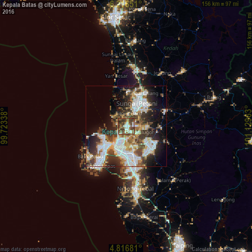
Analysis of Kepala Batas night lights 2016
Square area 10x10 km:
 9.71%
9.71%90-99
12.6%80-89
5.58%70-79
8.47%60-69
11.16%50-59
15.5%40-49
19.63%30-39
13.43%20-29
3.93%10-19
0%0-9
0%Square area 50x50 km:
10.53%90-99
8.7%80-89
3.47%70-79
4.08%60-69
4.75%50-59
5.03%40-49
6.34%30-39
7.37%20-29
9.06%10-19
10.46%0-9
30.2%Clear (daylight) street map image can be seen on geolist.org.
Map coordinates:
6° 12' 59.4" North, 99° 43' 24.2" East
5° 31' 1.5" North, 100° 25' 35.4" East
4° 49' 0.5" North, 101° 7' 46.7" East
Some cities around Kepala Batas sort by population:
• George Town
15.5 km =9.6 mi,  220°
220°
• Sungai Petani
16 km =9.9 mi,  25°
25°
• Bukit Mertajam
17.7 km =11 mi,  165°
165°
• Tasek Glugor
9 km =5.6 mi,  117°
117°
• Butterworth
14.8 km =9.2 mi,  207°
207°
• Perai
15.6 km =9.7 mi,  197°
197°
• Permatang Kuching
7.8 km =4.8 mi, 219°
• Tanjung Tokong
14.6 km =9.1 mi,  244°
244°
1735506 (p: 17,131)
Sources (retrieved 2019-11-25):
» Earth at Night: Flat Maps 2012, 2016