Tlahualilo de Zaragoza night lights from space
Night Light of Tlahualilo de Zaragoza (Durango) from space (Mexico) Src. Average luminocity for 10x10km area is 5.7004% and for 50x50km: 1.0142%.
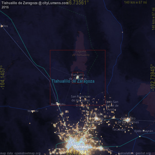
Analysis of Tlahualilo de Zaragoza night lights 2016
Square area 10x10 km:
 0.4%
0.4%90-99
0.4%80-89
0.79%70-79
0.79%60-69
1.39%50-59
1.98%40-49
0.6%30-39
0.2%20-29
1.59%10-19
0.2%0-9
91.67%Square area 50x50 km:
0.02%90-99
0.05%80-89
0.15%70-79
0.15%60-69
0.16%50-59
0.25%40-49
0.26%30-39
0.15%20-29
0.26%10-19
0.12%0-9
98.43%Clear (daylight) street map image can be seen on geolist.org.
Map coordinates:
26° 44' 8.2" North, 104° 8' 44.5" West
26° 6' 21.3" North, 103° 26' 33.3" West
25° 28' 22.2" North, 102° 44' 22" West
Some cities around Tlahualilo de Zaragoza sort by population:
• Gómez Palacio
59.8 km =37.2 mi,  185°
185°
• San Pedro
60.1 km =37.3 mi,  130°
130°
• Francisco I. Madero
40.8 km =25.4 mi,  155°
155°
• San Antonio del Coyote
48.4 km =30.1 mi, 161°
• Bermejillo
30.2 km =18.8 mi,  216°
216°
• Coyote
48.3 km =30 mi, 160°
• Concordia
48.7 km =30.3 mi,  138°
138°
• Mapimí
50.4 km =31.3 mi,  233°
233°
3981469 (p: 9,517)
Sources (retrieved 2019-11-25):
» Earth at Night: Flat Maps 2012, 2016