Concordia night lights from space
Night Light of Concordia (Coahuila) from space (Mexico) Src. Average luminocity for 10x10km area is 10.4867% and for 50x50km: 9.8212%.
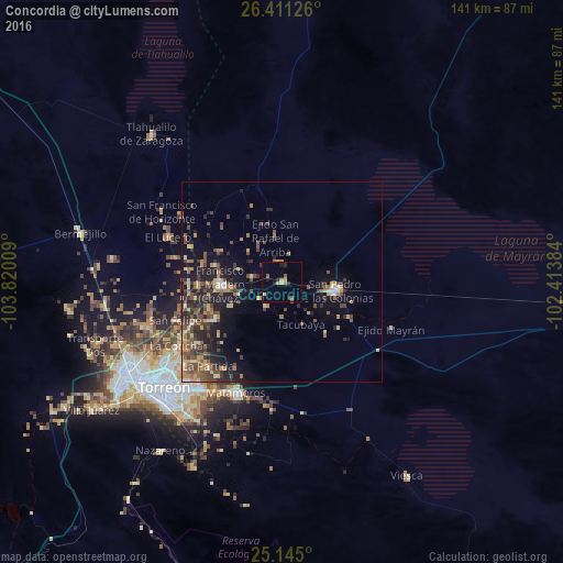
Analysis of Concordia night lights 2016
Square area 10x10 km:
 0%
0%90-99
0%80-89
1.7%70-79
2.84%60-69
2.08%50-59
1.89%40-49
0.19%30-39
1.14%20-29
3.6%10-19
0.95%0-9
85.61%Square area 50x50 km:
0.31%90-99
0.48%80-89
1.47%70-79
1.5%60-69
1.47%50-59
1.98%40-49
2.82%30-39
1.98%20-29
3.5%10-19
6.57%0-9
77.92%Clear (daylight) street map image can be seen on geolist.org.
Map coordinates:
26° 24' 40.5" North, 103° 49' 12.3" West
25° 46' 47.4" North, 103° 7' 1.1" West
25° 8' 42" North, 102° 24' 49.8" West
Some cities around Concordia sort by population:
• Torreón
40.1 km =24.9 mi,  229°
229°
• Gómez Palacio
44.6 km =27.7 mi,  238°
238°
• Matamoros
30.3 km =18.8 mi,  201°
201°
• San Pedro
13.6 km =8.5 mi,  101°
101°
• San Pedro
39.8 km =24.7 mi,  194°
194°
• Francisco I. Madero
15.5 km =9.6 mi,  267°
267°
• San Antonio del Coyote
19.4 km =12.1 mi, 240°
• Coyote
19.2 km =11.9 mi, 240°
4013024 (p: 7,858)
Sources (retrieved 2019-11-25):
» Earth at Night: Flat Maps 2012, 2016