San Pablo Huixtepec night lights from space
Night Light of San Pablo Huixtepec (Oaxaca) from space (Mexico) Src. Average luminocity for 10x10km area is 17.5519% and for 50x50km: 10.4659%.
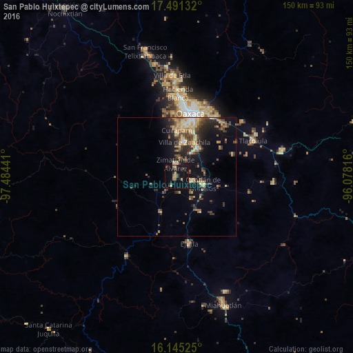
Analysis of San Pablo Huixtepec night lights 2016
Square area 10x10 km:
 0%
0%90-99
1.3%80-89
2.81%70-79
1.3%60-69
3.68%50-59
1.3%40-49
3.68%30-39
3.46%20-29
2.38%10-19
23.81%0-9
56.28%Square area 50x50 km:
0.31%90-99
1.23%80-89
1.93%70-79
1.79%60-69
1.21%50-59
1.33%40-49
2.49%30-39
2.02%20-29
2.79%10-19
7.53%0-9
77.38%Clear (daylight) street map image can be seen on geolist.org.
Map coordinates:
17° 29' 28.8" North, 97° 29' 3.9" West
16° 49' 10.1" North, 96° 46' 52.6" West
16° 8' 42.9" North, 96° 4' 41.4" West
Some cities around San Pablo Huixtepec sort by population:
• Santa Cruz Xoxocotlán
23.9 km =14.9 mi,  11°
11°
• Ocotlán de Morelos
11.8 km =7.3 mi,  105°
105°
• Villa de Zaachila
15 km =9.3 mi, 13°
• Vicente Guerrero
15.2 km =9.4 mi,  33°
33°
• Cuilapan de Guerrero
17.6 km =10.9 mi,  0°
0°
• Zimatlán de Álvarez
5.6 km =3.5 mi,  356°
356°
• San Agustín de las Juntas
22.7 km =14.1 mi,  19°
19°
• San Antonino Castillo Velasco
10.7 km =6.6 mi,  100°
100°
3518128 (p: 8,786)
Sources (retrieved 2019-11-25):
» Earth at Night: Flat Maps 2012, 2016