San Francisco Chimalpa night lights from space
Night Light of San Francisco Chimalpa (Morelos) from space (Mexico) Src. Average luminocity for 10x10km area is 61.3554% and for 50x50km: 64.191%.
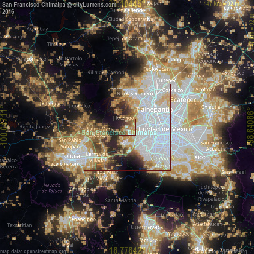
Analysis of San Francisco Chimalpa night lights 2016
Square area 10x10 km:
 4.13%
4.13%90-99
5.37%80-89
11.16%70-79
21.49%60-69
15.08%50-59
13.43%40-49
9.3%30-39
8.06%20-29
10.33%10-19
1.65%0-9
0%Square area 50x50 km:
28.87%90-99
9.16%80-89
7.78%70-79
7.7%60-69
8%50-59
4.61%40-49
4.92%30-39
4.15%20-29
6.31%10-19
6.36%0-9
12.13%Clear (daylight) street map image can be seen on geolist.org.
Map coordinates:
20° 6' 16" North, 100° 2' 49.6" West
19° 26' 34" North, 99° 20' 38.3" West
18° 46' 42.3" North, 98° 38' 27.1" West
Some cities around San Francisco Chimalpa sort by population:
• Delegación Cuajimalpa de Morelos
9.9 km =6.2 mi,  145°
145°
• Huixquilucan
9.2 km =5.7 mi,  184°
184°
• Jesús del Monte
9.2 km =5.7 mi, 145°
• La Magdalena Chichicaspa
3.9 km =2.4 mi, 150°
• Santiago Yancuitlalpan
7.7 km =4.8 mi, 147°
• Huixquilucan de Degollado
9.2 km =5.7 mi, 183°
• Zacamulpa
9.8 km =6.1 mi,  172°
172°
• San Bartolomé Coatepec
6 km =3.7 mi, 146°
3530852 (p: 8,953)
Sources (retrieved 2019-11-25):
» Earth at Night: Flat Maps 2012, 2016