Quintín Arauz night lights from space
Night Light of Quintín Arauz (Tabasco) from space (Mexico) Src. Average luminocity for 10x10km area is 55.3988% and for 50x50km: 22.193%.
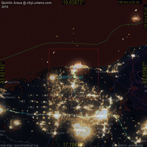
Analysis of Quintín Arauz night lights 2016
Square area 10x10 km:
 4.96%
4.96%90-99
8.88%80-89
18.39%70-79
5.17%60-69
3.93%50-59
7.64%40-49
13.22%30-39
12.6%20-29
20.45%10-19
4.75%0-9
0%Square area 50x50 km:
1.19%90-99
2.92%80-89
2.94%70-79
1.58%60-69
1.97%50-59
4.04%40-49
6.64%30-39
8.48%20-29
11.09%10-19
13.57%0-9
45.58%Clear (daylight) street map image can be seen on geolist.org.
Map coordinates:
19° 2' 19.4" North, 93° 55' 18.9" West
18° 22' 21.9" North, 93° 13' 7.6" West
17° 42' 15.1" North, 92° 30' 56.4" West
Some cities around Quintín Arauz sort by population:
• Comalcalco
12.2 km =7.6 mi,  182°
182°
• Paraiso
3.2 km =2 mi,  8°
8°
• Jalpa de Méndez
27.3 km =17 mi,  143°
143°
• Villa Tecolutilla
15.7 km =9.8 mi,  230°
230°
• Chichicapa
12.9 km =8 mi,  162°
162°
• Ayapa
20 km =12.4 mi,  145°
145°
• Miguel Hidalgo
16.1 km =10 mi,  216°
216°
• Villa Aldama
20.2 km =12.6 mi, 223°
3802097 (p: 5,178)
Sources (retrieved 2019-11-25):
» Earth at Night: Flat Maps 2012, 2016