Quila night lights from space
Night Light of Quila (Sinaloa) from space (Mexico) Src. Average luminocity for 10x10km area is 8.625% and for 50x50km: 3.6138%.
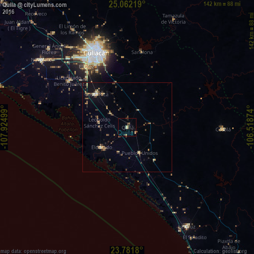
Analysis of Quila night lights 2016
Square area 10x10 km:
 0%
0%90-99
1.59%80-89
1.39%70-79
2.38%60-69
0.99%50-59
0%40-49
1.19%30-39
2.18%20-29
1.39%10-19
1.59%0-9
87.3%Square area 50x50 km:
0.04%90-99
0.34%80-89
0.49%70-79
0.53%60-69
0.48%50-59
0.53%40-49
1%30-39
0.86%20-29
0.7%10-19
1.58%0-9
93.44%Clear (daylight) street map image can be seen on geolist.org.
Map coordinates:
25° 3' 43.9" North, 107° 55' 30" West
24° 25' 25" North, 107° 13' 18.7" West
23° 46' 54.5" North, 106° 31' 7.5" West
Some cities around Quila sort by population:
• Culiacán
44.1 km =27.4 mi,  337°
337°
• Villa de Costa Rica
25.2 km =15.7 mi,  317°
317°
• Licenciado Benito Juárez (Campo Gobierno)
41.7 km =25.9 mi,  308°
308°
• Villa Juárez
41.5 km =25.8 mi, 309°
• El Rosario
19.1 km =11.9 mi,  168°
168°
• El Dorado
18.2 km =11.3 mi,  231°
231°
• Eldorado
18.4 km =11.4 mi, 233°
• El Diez
40.7 km =25.3 mi,  325°
325°
3991148 (p: 5,793)
Sources (retrieved 2019-11-25):
» Earth at Night: Flat Maps 2012, 2016