Piedras Negras night lights from space
Night Light of Piedras Negras (Veracruz) from space (Mexico) Src. Average luminocity for 10x10km area is 6.0682% and for 50x50km: 2.0055%.
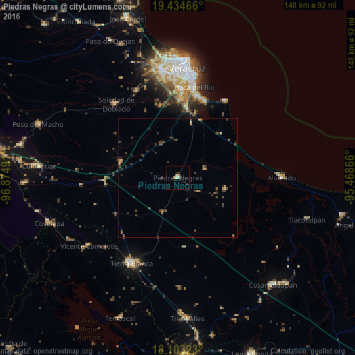
Analysis of Piedras Negras night lights 2016
Square area 10x10 km:
 0%
0%90-99
1.65%80-89
0.83%70-79
1.65%60-69
0%50-59
0%40-49
0%30-39
0.83%20-29
3.31%10-19
3.1%0-9
88.64%Square area 50x50 km:
0%90-99
0.13%80-89
0.22%70-79
0.27%60-69
0.33%50-59
0.29%40-49
0.53%30-39
0.83%20-29
0.63%10-19
0.45%0-9
96.32%Clear (daylight) street map image can be seen on geolist.org.
Map coordinates:
19° 26' 4.8" North, 96° 52' 29.7" West
18° 46' 12.9" North, 96° 10' 18.4" West
18° 6' 11.6" North, 95° 28' 7.2" West
Some cities around Piedras Negras sort by population:
• La Isla
19.1 km =11.9 mi,  173°
173°
• Soledad de Doblado
40.4 km =25.1 mi,  319°
319°
• El Tejar
33.8 km =21 mi,  1°
1°
• Boca del Rio
37.9 km =23.5 mi,  10°
10°
• Fraccionamiento Arboledas San Ramón
36.1 km =22.4 mi, 2°
• Antón Lizardo
37.3 km =23.2 mi,  30°
30°
• Manlio Fabio Altamirano
39.8 km =24.7 mi,  334°
334°
• Paso del Toro
29.7 km =18.5 mi, 7°
3521482 (p: 8,767)
Sources (retrieved 2019-11-25):
» Earth at Night: Flat Maps 2012, 2016