El Tejar night lights from space
Night Light of El Tejar (Veracruz) from space (Mexico) Src. Average luminocity for 10x10km area is 59.829% and for 50x50km: 17.6058%.
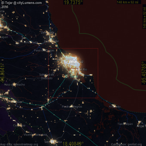
Analysis of El Tejar night lights 2016
Square area 10x10 km:
 2.38%
2.38%90-99
10.17%80-89
10.39%70-79
17.32%60-69
13.85%50-59
8.44%40-49
12.99%30-39
10.39%20-29
9.52%10-19
4.55%0-9
0%Square area 50x50 km:
3.1%90-99
3.23%80-89
2.13%70-79
2.49%60-69
2.21%50-59
1.98%40-49
3.06%30-39
3.14%20-29
3.72%10-19
7.17%0-9
67.77%Clear (daylight) street map image can be seen on geolist.org.
Map coordinates:
19° 44' 15" North, 96° 51' 50.8" West
19° 4' 27.6" North, 96° 9' 39.5" West
18° 24' 30.6" North, 95° 27' 28.3" West
Some cities around El Tejar sort by population:
• Veracruz
12 km =7.5 mi,  9°
9°
• Valente Diaz
11.5 km =7.1 mi,  329°
329°
• Las Amapolas
9.5 km =5.9 mi,  335°
335°
• Fraccionamiento Geovillas los Pinos
17.3 km =10.7 mi, 336°
• Boca del Rio
6.9 km =4.3 mi,  60°
60°
• Fraccionamiento Arboledas San Ramón
2.3 km =1.4 mi, 11°
• Antón Lizardo
17.8 km =11.1 mi,  95°
95°
• Paso del Toro
5.1 km =3.2 mi,  148°
148°
3528046 (p: 11,168)
Sources (retrieved 2019-11-25):
» Earth at Night: Flat Maps 2012, 2016