Emiliano Zapata night lights from space
Night Light of Emiliano Zapata (Baja California) from space (Mexico) Src. Average luminocity for 10x10km area is 14.2343% and for 50x50km: 1.7961%.
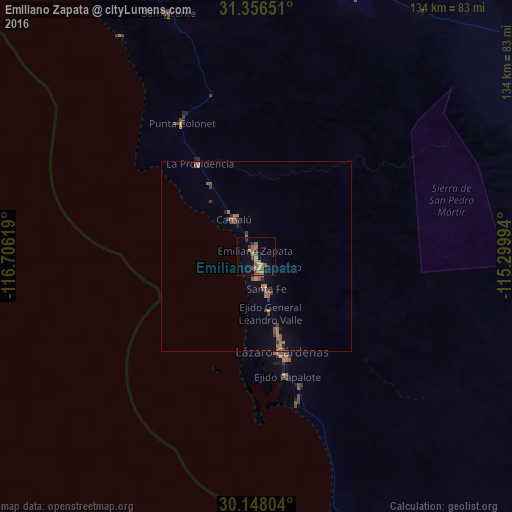
Analysis of Emiliano Zapata night lights 2016
Square area 10x10 km:
 0%
0%90-99
0%80-89
1.05%70-79
0.87%60-69
5.94%50-59
5.59%40-49
2.8%30-39
2.62%20-29
1.05%10-19
2.97%0-9
77.1%Square area 50x50 km:
0%90-99
0%80-89
0.04%70-79
0.07%60-69
0.73%50-59
0.73%40-49
0.4%30-39
0.44%20-29
0.21%10-19
0.28%0-9
97.1%Clear (daylight) street map image can be seen on geolist.org.
Map coordinates:
31° 21' 23.4" North, 116° 42' 22.3" West
30° 45' 15" North, 116° 0' 11" West
30° 8' 52.9" North, 115° 17' 59.8" West
Some cities around Emiliano Zapata sort by population:
• Ensenada
136.6 km =84.9 mi,  335°
335°
• Rodolfo Sánchez Taboada
120.3 km =74.8 mi,  333°
333°
• San Felipe
115.1 km =71.5 mi,  74°
74°
• Lázaro Cárdenas
26.2 km =16.3 mi,  163°
163°
• Vicente Guerrero
2.8 km =1.7 mi, 155°
• El Sauzal de Rodríguez
142.6 km =88.6 mi, 332°
• Camalú
11.4 km =7.1 mi, 329°
• Benito García (El Zorrillo)
112.8 km =70.1 mi, 334°
8858241 (p: 5,756)
Sources (retrieved 2019-11-25):
» Earth at Night: Flat Maps 2012, 2016