Campo Sesenta night lights from space
Night Light of Campo Sesenta (Sonora) from space (Mexico) Src. Average luminocity for 10x10km area is 4.1607% and for 50x50km: 7.7006%.
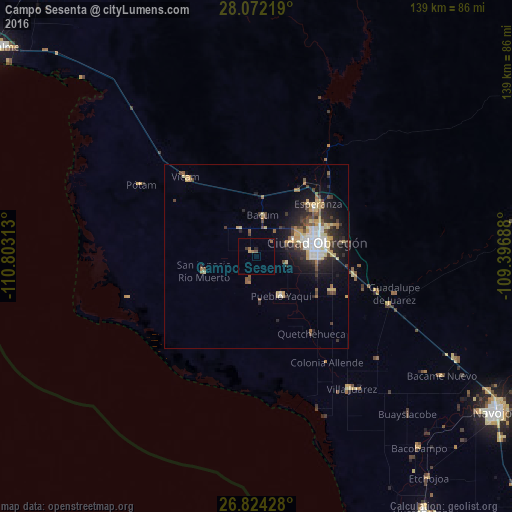
Analysis of Campo Sesenta night lights 2016
Square area 10x10 km:
 0%
0%90-99
0%80-89
0.2%70-79
0.6%60-69
2.38%50-59
0%40-49
0.79%30-39
0.79%20-29
0.79%10-19
0%0-9
94.44%Square area 50x50 km:
1%90-99
1.13%80-89
1.27%70-79
1.14%60-69
0.57%50-59
0.93%40-49
1.26%30-39
1.08%20-29
2.4%10-19
4.37%0-9
84.84%Clear (daylight) street map image can be seen on geolist.org.
Map coordinates:
28° 4' 19.9" North, 110° 48' 11.3" West
27° 27' 0" North, 110° 6' 0" West
26° 49' 27.4" North, 109° 23' 48.8" West
Some cities around Campo Sesenta sort by population:
• Ciudad Obregón
16.2 km =10.1 mi,  75°
75°
• Esperanza
22.1 km =13.7 mi,  49°
49°
• Pueblo Yaqui
12.4 km =7.7 mi,  148°
148°
• El Tobarito
22.2 km =13.8 mi,  113°
113°
• Marte R. Gómez (Tobarito)
23 km =14.3 mi, 113°
• Cocorit
19.7 km =12.2 mi,  44°
44°
• San Ignacio Río Muerto
14.9 km =9.3 mi,  255°
255°
• Francisco Javier Mina
1.6 km =1 mi,  326°
326°
4015842 (p: 6,012)
Sources (retrieved 2019-11-25):
» Earth at Night: Flat Maps 2012, 2016