Bajos de Chila night lights from space
Night Light of Bajos de Chila (Oaxaca) from space (Mexico) Src. Average luminocity for 10x10km area is 6.5498% and for 50x50km: 1.5296%.
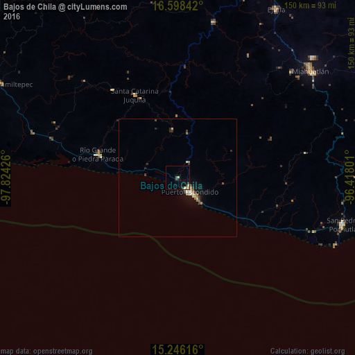
Analysis of Bajos de Chila night lights 2016
Square area 10x10 km:
 0%
0%90-99
0.87%80-89
1.3%70-79
1.3%60-69
0%50-59
0.22%40-49
2.81%30-39
0.22%20-29
1.08%10-19
2.38%0-9
89.83%Square area 50x50 km:
0.04%90-99
0.24%80-89
0.28%70-79
0.18%60-69
0.23%50-59
0.18%40-49
0.24%30-39
0.25%20-29
0.21%10-19
0.93%0-9
97.21%Clear (daylight) street map image can be seen on geolist.org.
Map coordinates:
16° 35' 54.3" North, 97° 49' 27.3" West
15° 55' 24.3" North, 97° 7' 16.1" West
15° 14' 46.2" North, 96° 25' 4.8" West
Some cities around Bajos de Chila sort by population:
• Puerto Escondido
7.5 km =4.7 mi,  141°
141°
• Miahuatlán de Porfirio Díaz
72.3 km =44.9 mi,  50°
50°
• San Pedro Pochutla
72.8 km =45.2 mi,  105°
105°
• Río Grande
35 km =21.7 mi,  286°
286°
• Brisas de Zicatela
12.8 km =8 mi, 138°
• Santa Catarina Juquila
39.5 km =24.5 mi,  332°
332°
• San Miguel Panixtlahuaca
46.4 km =28.8 mi,  323°
323°
• Santos Reyes Nopala
20.6 km =12.8 mi,  353°
353°
3800562 (p: 5,425)
Sources (retrieved 2019-11-25):
» Earth at Night: Flat Maps 2012, 2016