Rivière du Rempart night lights from space
Night Light of Rivière du Rempart from space (Mauritius) Src. Average luminocity for 10x10km area is 11.2262% and for 50x50km: 14.5515%.
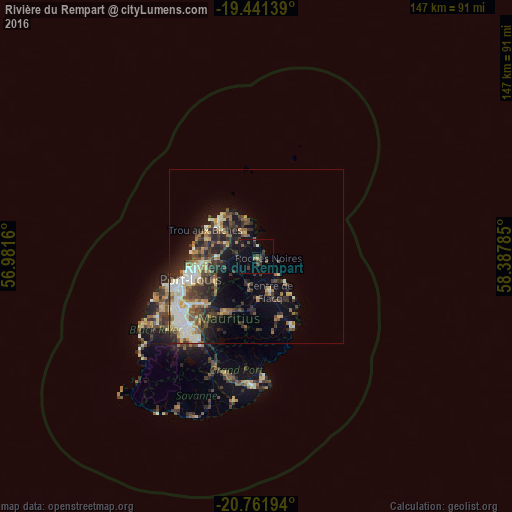
Analysis of Rivière du Rempart night lights 2016
Square area 10x10 km:
 0%
0%90-99
0.2%80-89
1.19%70-79
0.2%60-69
0.79%50-59
1.39%40-49
3.77%30-39
5.16%20-29
4.76%10-19
6.35%0-9
76.19%Square area 50x50 km:
1.6%90-99
2.85%80-89
1.78%70-79
1.47%60-69
1.61%50-59
1.83%40-49
3.06%30-39
3.28%20-29
4.81%10-19
6.25%0-9
71.45%Clear (daylight) street map image can be seen on geolist.org.
Map coordinates:
19° 26' 29" South, 56° 58' 53.8" East
20° 6' 11" South, 57° 41' 5" East
20° 45' 43" South, 58° 23' 16.3" East
Some cities around Rivière du Rempart sort by population:
• Goodlands
8 km =5 mi,  333°
333°
• Lalmatie
9.9 km =6.2 mi,  194°
194°
• Brisée Verdière
7.8 km =4.8 mi,  210°
210°
• Poste de Flacq
8.2 km =5.1 mi,  144°
144°
• Bon Accueil
8.1 km =5 mi,  201°
201°
• Laventure
4.8 km =3 mi, 190°
• Piton
5.9 km =3.7 mi,  284°
284°
• Roches Noire
3 km =1.9 mi,  107°
107°
934091 (p: 11,675)
Sources (retrieved 2019-11-25):
» Earth at Night: Flat Maps 2012, 2016