Siġġiewi night lights from space
Night Light of Siġġiewi (Is-Siġġiewi) from space (Malta) Src. Average luminocity for 10x10km area is 60.958% and for 50x50km: 10.2322%.
Analysis of Siġġiewi night lights 2016
Square area 10x10 km:
100  14.69%
90-99 14.86%
80-89 5.59%
70-79 10.49%
60-69 10.14%
50-59 5.07%
40-49 7.87%
30-39 6.29%
20-29 9.09%
10-19 11.36%
0-9 4.55%
14.69%90-99
14.86%80-89
5.59%70-79
10.49%60-69
10.14%50-59
5.07%40-49
7.87%30-39
6.29%20-29
9.09%10-19
11.36%0-9
4.55%Square area 50x50 km:
100 1.77%
90-99 1.98%
80-89 1.13%
70-79 1.39%
60-69 1.92%
50-59 0.67%
40-49 1.12%
30-39 1.38%
20-29 2.52%
10-19 5.72%
0-9 80.4%
1.77%90-99
1.98%80-89
1.13%70-79
1.39%60-69
1.92%50-59
0.67%40-49
1.12%30-39
1.38%20-29
2.52%10-19
5.72%0-9
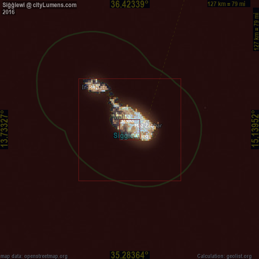
80.4%Clear (daylight) street map image can be seen on geolist.org.
Map coordinates:
36° 25' 24.2" North, 13° 43' 59.8" East
35° 51' 20" North, 14° 26' 11" East
35° 17' 1.1" North, 15° 8' 22.3" East
Some cities around Siġġiewi sort by population:
• Qormi
3.9 km =2.4 mi,  54°
54°
• Haz-Zebbug
1.9 km =1.2 mi,  13°
13°
• Attard
3.8 km =2.4 mi, 8°
• Żurrieq
4.4 km =2.7 mi,  128°
128°
• Rabat
4.5 km =2.8 mi,  310°
310°
• Mqabba
3 km =1.9 mi,  107°
107°
• Qrendi
3 km =1.9 mi,  139°
139°
• Kirkop
4.6 km =2.9 mi, 108°
2562504 (p: 7,676)
Sources (retrieved 2019-11-25):
» Earth at Night: Flat Maps 2012, 2016