Zintan night lights from space
Night Light of Zintan (Jabal al Gharbi) from space (Libya) Src. Average luminocity for 10x10km area is 58.0857% and for 50x50km: 6.6053%.
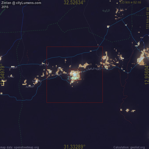
Analysis of Zintan night lights 2016
Square area 10x10 km:
 5.42%
5.42%90-99
5.24%80-89
25.35%70-79
15.38%60-69
1.75%50-59
4.55%40-49
7.52%30-39
4.72%20-29
16.43%10-19
13.46%0-9
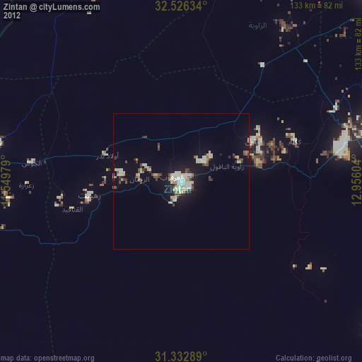
0.17%Square area 50x50 km:
0.27%90-99
0.3%80-89
1.92%70-79
1.36%60-69
0.42%50-59
0.61%40-49
1.06%30-39
0.9%20-29
1.41%10-19
6.15%0-9
85.59%Clear (daylight) street map image can be seen on geolist.org.
Map coordinates:
32° 31' 34.8" North, 11° 32' 59.2" East
31° 55' 53.6" North, 12° 15' 10.5" East
31° 19' 58.4" North, 12° 57' 21.7" East
Some cities around Zintan sort by population:
• Al Ajaylat
92.5 km =57.5 mi,  7°
7°
• Şabrātah
98.3 km =61.1 mi, 12°
• Gharyan
77.1 km =47.9 mi,  69°
69°
• Yafran
29.8 km =18.5 mi,  60°
60°
• Mizdah
87.6 km =54.4 mi,  127°
127°
• Şurmān
96.5 km =60 mi,  18°
18°
• Giado
21.3 km =13.2 mi,  277°
277°
• Al ‘Azīzīyah
98.1 km =61 mi,  47°
47°
2218963 (p: 33,000)
Sources (retrieved 2019-11-25):
» Earth at Night: Flat Maps 2012, 2016