Līgatne night lights from space
Night Light of Līgatne from space (Latvia) Src. Average luminocity for 10x10km area is 0.2429% and for 50x50km: 0.7839%.
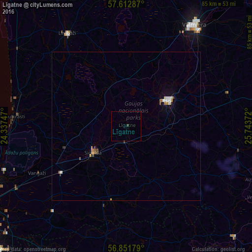
Analysis of Līgatne night lights 2016
Square area 10x10 km:
100  0%
0%
90-99 0%
80-89 0%
70-79 0%
60-69 0%
50-59 0%
40-49 0.48%
30-39 0%
20-29 0%
10-19 0%
0-9 99.52%
0%90-99
0%80-89
0%70-79
0%60-69
0%50-59
0%40-49
0.48%30-39
0%20-29
0%10-19
0%0-9
99.52%Square area 50x50 km:
100 0.11%
90-99 0.14%
80-89 0.04%
70-79 0.13%
60-69 0.09%
50-59 0.07%
40-49 0.17%
30-39 0.08%
20-29 0.02%
10-19 0.22%
0-9 98.91%
0.11%90-99
0.14%80-89
0.04%70-79
0.13%60-69
0.09%50-59
0.07%40-49
0.17%30-39
0.08%20-29
0.02%10-19
0.22%0-9
98.91%Clear (daylight) street map image can be seen on geolist.org.
Map coordinates:
57° 36' 46.3" North, 24° 20' 14.9" East
57° 14' 3.4" North, 25° 2' 26.1" East
56° 51' 6.4" North, 25° 44' 37.4" East
Some cities around Līgatne sort by population:
• Cēsis
16.5 km =10.3 mi,  58°
58°
• Sigulda
14.1 km =8.8 mi,  230°
230°
• Priekuļi
21.3 km =13.2 mi,  65°
65°
• Loja
25.6 km =15.9 mi,  249°
249°
• Mālpils
25.4 km =15.8 mi,  191°
191°
• Ragana
20.9 km =13 mi, 253°
• Stalbe
15.2 km =9.4 mi,  357°
357°
• Drabeši
14.3 km =8.9 mi,  86°
86°
457912 (p: 1,433)
Sources (retrieved 2019-11-25):
» Earth at Night: Flat Maps 2012, 2016