Glubokoye night lights from space
Night Light of Glubokoye (East Kazakhstan) from space (Kazakhstan) Src. Average luminocity for 10x10km area is 0.0588% and for 50x50km: 2.4934%.
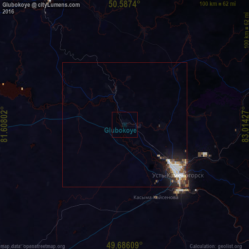
Analysis of Glubokoye night lights 2016
Square area 10x10 km:
 0%
0%90-99
0%80-89
0%70-79
0%60-69
0%50-59
0%40-49
0%30-39
0%20-29
0%10-19
0%0-9
100%Square area 50x50 km:
0.47%90-99
0.49%80-89
0.29%70-79
0.21%60-69
0.21%50-59
0.38%40-49
0.35%30-39
0.38%20-29
0.84%10-19
1.38%0-9
94.98%Clear (daylight) street map image can be seen on geolist.org.
Map coordinates:
50° 35' 14.6" North, 81° 36' 28.9" East
50° 8' 19.9" North, 82° 18' 40.1" East
49° 41' 9.9" North, 83° 0' 51.4" East
Some cities around Glubokoye sort by population:
• Ust-Kamenogorsk
28.1 km =17.5 mi,  131°
131°
• Ridder
88.5 km =55 mi,  75°
75°
• Shemonaīkha
61.3 km =38.1 mi,  332°
332°
• Belousovka
15.2 km =9.4 mi,  92°
92°
• Ūst’-Talovka
56.2 km =34.9 mi,  324°
324°
• Zhanga Buqtyrma
103.8 km =64.5 mi,  123°
123°
• Asūbulaq
84.2 km =52.3 mi,  140°
140°
• Staroaleyskoye, RU
98.9 km =61.5 mi,  347°
347°
1524227 (p: 11,192)
Sources (retrieved 2019-11-25):
» Earth at Night: Flat Maps 2012, 2016