Yŏnmu night lights from space
Night Light of Yŏnmu (Chungcheongnam-do) from space (South Korea) Src. Average luminocity for 10x10km area is 29.1612% and for 50x50km: 19.9593%.
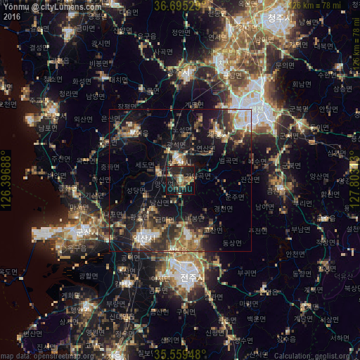

Analysis of Yŏnmu night lights 2016
Square area 10x10 km:
 0%
0%90-99
2.75%80-89
1.28%70-79
4.58%60-69
7.69%50-59
6.78%40-49
2.01%30-39
7.33%20-29
16.85%10-19
39.19%0-9
11.54%Square area 50x50 km:
1.76%90-99
2.77%80-89
1.55%70-79
2.21%60-69
3.33%50-59
3.75%40-49
3.03%30-39
5.4%20-29
7.37%10-19
14.57%0-9
54.26%Clear (daylight) street map image can be seen on geolist.org.
Map coordinates:
36° 41' 43" North, 126° 23' 48.8" East
36° 7' 46" North, 127° 6' 0" East
35° 33' 34.1" North, 127° 48' 11.3" East
Some cities around Yŏnmu sort by population:
• Daejeon
35.4 km =22 mi,  46°
46°
• Jeonju
34.5 km =21.4 mi,  172°
172°
• Iksan
24.4 km =15.2 mi,  212°
212°
• Wanju
31.9 km =19.8 mi, 172°
• Gongju
36.3 km =22.6 mi,  3°
3°
• Nonsan
8.4 km =5.2 mi,  350°
350°
• Buyeo
23.5 km =14.6 mi,  313°
313°
• Kinzan
35.1 km =21.8 mi,  94°
94°
1886598 (p: 25,015)
Sources (retrieved 2019-11-25):
» Earth at Night: Flat Maps 2012, 2016