Yongsan-dong night lights from space
Night Light of Yongsan-dong (Seoul) from space (South Korea) Src. Average luminocity for 10x10km area is 99.8636% and for 50x50km: 86.069%.
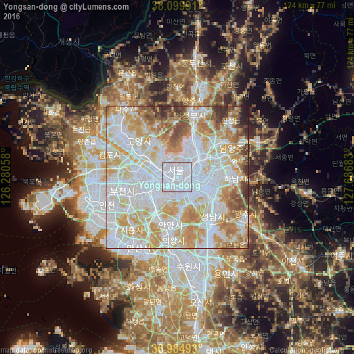
Analysis of Yongsan-dong night lights 2016
Square area 10x10 km:
 92.05%
90-99
7.95%80-89
0%70-79
0%60-69
0%50-59
0%40-49
0%30-39
0%20-29
0%10-19
0%0-9
0%Square area 50x50 km:
34.93%90-99
22.85%80-89
13.46%70-79
11.72%60-69
6.73%50-59
3.98%40-49
3.26%30-39
2.05%20-29
0.81%10-19
0.21%0-9
0%Clear (daylight) street map image can be seen on geolist.org.
Map coordinates:
38° 5' 59.7" North, 126° 16' 50.1" East
37° 32' 40.2" North, 126° 59' 1.3" East
36° 59' 5.7" North, 127° 41' 12.6" East
Some cities around Yongsan-dong sort by population:
• Seoul
2.4 km =1.5 mi,  348°
348°
• Goyang-si
18.1 km =11.2 mi,  313°
313°
• Seongnam-si
18 km =11.2 mi,  130°
130°
• Bucheon-si
18.4 km =11.4 mi,  254°
254°
• Anyang-si
17.6 km =10.9 mi,  196°
196°
• Kwangmyŏng
12.8 km =8 mi,  234°
234°
• Guri-si
15 km =9.3 mi,  66°
66°
• Hanam
19.6 km =12.2 mi,  91°
91°
6800487 (p: 12,612)
Sources (retrieved 2019-11-25):
» Earth at Night: Flat Maps 2012, 2016